the Creative Commons Attribution 4.0 License.
the Creative Commons Attribution 4.0 License.
 | 03 Nov 2025
Historical background of Paleo Mega Lake of Rey
Donya Namdar
Over the past decade, geological and historical evidence has increasingly suggested the existence of a vast ancient lake in central Iran, herein referred to as the Paleo Mega Lake of Rey (PAMELA). This study employs an interdisciplinary methodology to identify and geographically correlate historical references and terminologies associated with the lake. By analyzing over 350 sources, including travelogues, city histories, and ancient religious texts, we reconstructed the probable location, hydrological timeline, and cultural impact of the lake. Findings suggest that PAMELA has been referenced by various historical names such as Faraxkurt and Saveh Lake, and that it significantly influenced the livelihood of ancient communities. The integrated analysis points to a high probability of sustained water presence between 10 000 BCE and the 6th century CE.
- Article
(2989 KB) - Full-text XML
-
Supplement
(521 KB) - BibTeX
- EndNote


In recent years, growing interest has emerged regarding the hypothesis of a vast paleolake in central Iran referred to herein as the Paleo Mega Lake of Rey (PAMELA). While previous studies have described scattered geomorphic evidence, a cohesive reconstruction of PAMELA's extent and significance remains absent. This study formulates a testable hypothesis: that a unified pluvial system, historically known under names such as Farakhkurt and Saveh Lake, once occupied a large portion of the central Iranian plateau. Through the integration of geological, paleoclimatic, and historiographical data, we aim to reconstruct this lake's spatial boundaries and assess its long-term impact on regional cultural and ecological systems. Through a multidisciplinary approach involving classical texts, historical accounts, and sedimentary data, we seek to reconstruct the spatial and temporal dynamics of this ancient lake and assess its role in shaping the human history of the region.
Over the last decades, research on ancient and pluvial lakes has demonstrated their global significance for reconstructing past climate and human settlement histories. In North America, classic cases such as Lake Bonneville and Lake Lahontan in the Great Basin have been extensively studied through geomorphological mapping and geochronology, showing how moisture fluctuations tied to glacial–interglacial cycles created large, interconnected basins (Chen and Maloof, 2017; Reheis et al., 2014).
In Africa, the most prominent example is Mega-Lake Chad, which during the Holocene African Humid Period expanded to an area of about 360 000 km2 and depths exceeding 150 m. Its reconstructed shorelines and sediment cores not only constrain regional hydroclimate variability but also illustrate strong feedbacks between lake extent and the strength of the West African monsoon (Armitage et al., 2015; Ghienne et al., 2002).
In South America, studies of the Andean Altiplano have resolved the Tauca (ca. 16–12 ka) and Minchin (> 30 ka) lake phases using a combination of U–Th dating of tufas, sediment cores, and geomorphic analyses (Fornari et al., 2001; Placzek et al., 2006). These examples highlight how different methodological toolkits ranging from digital elevation models to multiproxy paleolimnology converge to build precise histories of past hydroclimate.
Within this global framework, Iranian basins occupy a critical position at the climatic intersection of the Mediterranean Westerlies and the Indian Summer Monsoon. Regional studies, including sediment cores from Lake Hamoun (Hamzeh et al., 2016), multiproxy reconstructions from the Jazmurian playa (Vaezi et al., 2019), and nationwide paleohydrological modeling (Shoaee et al., 2023), provide important evidence that Iranian closed basins have repeatedly captured regional moisture anomalies comparable to those in the Great Basin, Sahara–Sahel, and Altiplano.
Early geological evidence of lacustrine activity in the Rey region, located south of Tehran, was reported by several researchers (Berberian, 2014; Berberian and Yeats, 2016; Krinsley, 1970; Nazari et al., 2010; Rieben, 1966). These studies described sedimentary formations consistent with ancient shoreline dynamics, yet no integrative framework had been proposed to define the broader basin. This gap was addressed in 2021 when Jarahi introduced the first comprehensive paleolake model, naming it the Paleo Mega Lake of Rey (PAMELA) (Jarahi, 2021). His approach combined high-resolution digital elevation models from the ALOS PALSAR satellite with geo-historical analyses of ancient texts and regional topography. The reconstructed extent of PAMELA spans not only central Iran but potentially reaches into western Afghanistan and eastern Pakistan. Recent morphometric simulations modeling (Namdar et al., 2025a, b, c) suggest that PAMELA was among the largest Holocene lacustrine systems in southwest Asia. While sedimentological data indicate its formation began in the Late Pleistocene, the lake reached peak levels during the Early Holocene, corresponding to major climatic fluctuations.
This study employs an interdisciplinary, multi-proxy methodology that integrates paleoclimatic archives, historical textual analysis, geomorphological assessment, and GIS-based spatial modeling to reconstruct environmental transformations in central-eastern Iran during the Holocene. The methodological framework is structured into three interconnected phases.
3.1 Historical Textual Analysis and Semantic Interpretation
A corpus of over 350 historical texts including Islamic-era chronicles, geographical compendia, travel narratives, and Persian epic literature was systematically examined. Key environmental lexemes such as lakes, navigation, coasts, and fish were extracted using NVivo v12 to facilitate semantic mapping and thematic clustering. Each textual reference was geotemporally contextualized through cross-dated anchors such as dynastic periods, toponyms, and climatological metaphors, following the methodological protocol outlined by Djamali et al. (2018). Ambiguous, anachronistic, or temporally indeterminate entries were excluded to ensure analytical robustness and temporal precision.
3.2 Paleogeographic Reconstruction and Remote Sensing Integration
High-resolution ALOS PALSAR digital elevation models (12.5 m) and multispectral Landsat-8 imagery (2013–2023) were employed to generate elevation models and hydromorphic characterizations across the Haj Aligholi Playa (Lake Hecatompylos; Namdar et al., 2025a) and the hypothesized paleo mega Lake of Ray. Paleo-shorelines were delineated through slope-break detection along topographic transects and subsequently cross-validated with historical attestations of aquatic transport, ichthyofaunal presence, and littoral habitation. Geospatial referencing of lacustrine features was executed in ArcGIS Pro 3.1 using calibrated elevation bands and verified basemaps. Semantic intersections between spatial datasets and textual markers (e.g., boat, fish, coast) were integrated into vectorized geodatabases, following the procedures established by Pourali et al. (2023).
3.3 Climatic Correlation and Multi-Source Data Synthesis
To synchronize historical narrative data with Holocene climate variability, we incorporated high-resolution paleoclimatic proxies, including speleothem-derived humidity indices from the Zagros Mountains, sediment cores from Lakes Hamoun and Seistan, and regional syntheses by Hamzeh et al. (2016) and Kakroodi et al. (2015). A diachronic timeline (see Fig. 1) overlays inferred relative humidity fluctuations with distinct cultural epochs. Environmental dynamics particularly lake-level variability during the mid-Holocene aridification were interpreted through an integrated lens combining metaphorical textual indicators (e.g., “abundant fish” or “the boat path disappeared”) with geospatial and climatological records. Temporal cross-validation ensured alignment between literary motifs and independently established climate transitions.
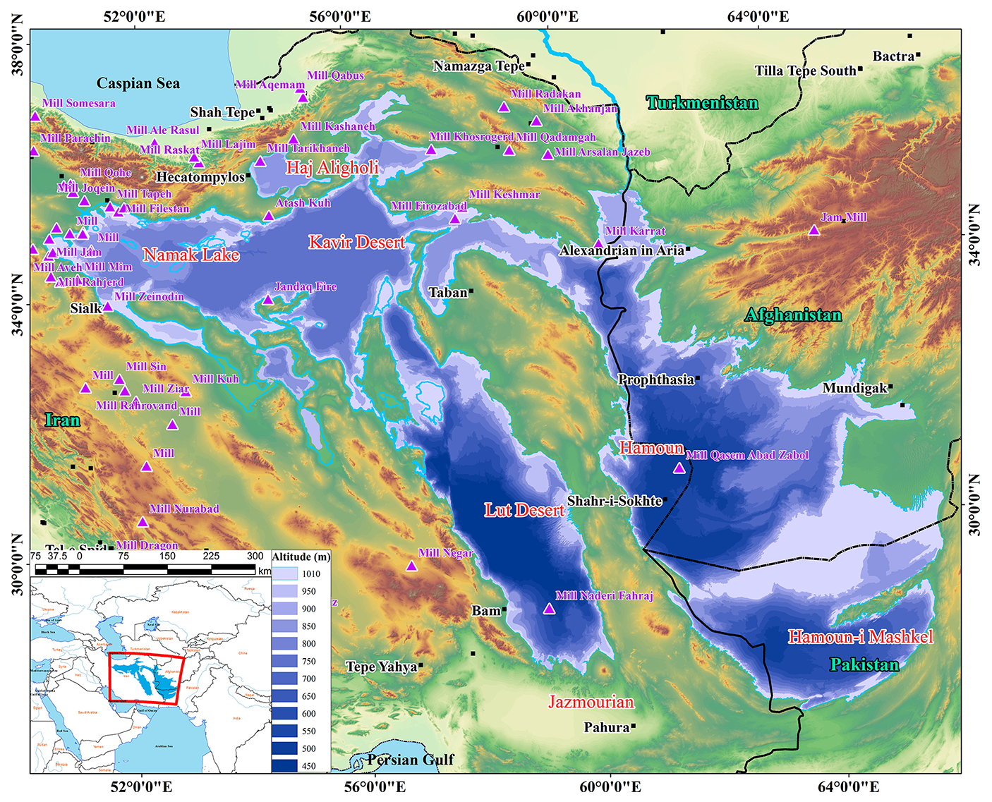
Figure 1The geographical location of the ancient Lake of Rey is depicted with changing shades from dark to light blue. This lake covered parts of three countries: Iran, Afghanistan, and Pakistan (Jarahi, 2021). Important deserts are marked in red, and ancient sites are shown in black. Purple triangles represent mill hills. The positions of the mill hills near the lake's shore correspond entirely to ports and shallow coastlines. The given digital elevation data is accurate to 12.5 m, obtained from the AleosPalsar satellite.
3.4 Methodological transferability and precedent
The integrated approach employed in this study combining digital elevation models (DEMs) and satellite imagery for paleoshoreline mapping with historical textual evidence and geomorphic observations follows established practices in global paleolake research. For instance, high-resolution DEM and LiDAR analyses have been widely applied to reconstruct strandlines and tectonic deformation in the Lake Bonneville system of the western United States (Baran and Cardenas, 2025; Chen and Maloof, 2017). Multiproxy sediment cores coupled with U–Th chronology have resolved lake phases such as Tauca and Minchin on the Andean Altiplano (Fornari et al., 2001; Placzek et al., 2006). Moreover, geo-historical syntheses combining chronicles with geological evidence have successfully reconstructed Caspian Sea level fluctuations during the last millennium (Naderi Beni et al., 2013). These precedents demonstrate both the validity of our chosen methods and their portability to other closed-basin systems across Southwest Asia and beyond.
4.1 Zoroastrian and Cosmological Literature
Ancient Zoroastrian texts, particularly the Avesta and the Bundahishn, repeatedly refer to a vast, life-sustaining body of water known as Vourukasha or Farakhkurt. This sacred lake is described as located near the mythical Alborz range and is considered the origin of all terrestrial waters. Later Avestan commentaries and Pahlavi texts also reference the Kashi Sea (Daryā-ye Kāshi), a water body sometimes interpreted as being in central Iran. Pourdavoud (Hintze, 2009; Pourdavoud, 2015) argue that such references may not be purely mythological but echo older geographic realities. Recent philological and spatial analyses by Oryan (Oryan, 2021) identify linguistic and geographical correspondences between these sacred descriptions and the hypothesized boundaries of the Paleo Mega Lake of Rey (PAMELA), particularly along the southern flanks of the Alborz Mountains.
4.2 Sassanid and Islamic Historiography
Textual sources from the Sassanid era and the early Islamic centuries offer increasingly localized and administrative references to a large inland lake occupying the Rey–Saveh corridor. According to Tarikh-e-Qom (Qomi and Qomi, 1934), during the reign of King Goudarz (91 BCE), a sizable body of water extended between Rey and Saveh. By the 6th century CE, Athar al-Bilad by Qazvini (1275a) reports that the lake had desiccated. Meanwhile, Kateb (Kateb, 1458) describes the founding of port towns such as Bargīn under Yazdgird II (r. 421–439 CE). These ports linked interior cities such as Meybod and Bideh which are situated near the 1000 m elevation and are interpreted as shoreline settlements along the margins of the paleo-lake (Table 1, Fig. 2).
4.3 Modern Travel Accounts and Observational Geography
In the late 19th and early 20th centuries, European geographers and explorers revived interest in the possibility of a large paleolake once spanning the central Iranian plateau. Emmerick and Macuch (Emmerick and Macuch, 2008) reported lacustrine sedimentary layers east of Saveh, consistent with the presence of ancient shoreline activity. The Swedish explorer Sven Hedin (Hedin, 1910) documented pronounced paleo-shoreline features between Jandagh and Torud and noted that the city gate of Jandagh had been reconstructed using ship timber salvaged from a vessel that had run aground in the vicinity suggesting former navigability. Additional reports by Gabriel (1939), Siroux (1949), and Rajabi (2004) referenced the ruins of long-abandoned port towns such as Barajin, Barjin, and Parchin. Although lacking formal archaeological verification, these observations align closely with geomorphological and sedimentological profiles supporting a historical lacustrine presence in the region.

Curtis (1990) argues that in the expansive arid expanse of the Great Desert and the Lut Desert, there once extended a vast lake. Haghighat (1962), recounting the history of the city of Semnan, reports that some 2000 years prior to the Common Era, King Tahmures erected the city of Semnan on the banks of Lake Saveh. He also elucidates the formation of the Iranian Plateau, highlighting that the southern lands of Semnan once comprised coastlines and plains. Tarih-e-Qomi (Qomi, 1934) alludes to an extensive lake spanning from Rey to Saveh during the reign of the Arsacid Kings (specifically, Goudarz in 91 BC). This perspective is further reinforced by the assertions of Strange (1930).
Kateb (1458), in reference to Yazdgird II, one of the Persian monarchs (reigning from 421 to 439 CE), conveys the following: Yazdgird commanded three generals: Mibodar, Bidar, and Eqdar. He instructed them to establish three cities. Mibodar founded Mibod, Eqdar established Eqdā, renowned for its association with the Gabars village. Bidar laid the foundations of Bidah. These three cities were served by a port known as Bargīn, located along the shores of Lake Saveh. This port was situated at a distance of 11 Farsangs (an ancient Iranian unit of length equivalent to approximately 6 km) from Yazd (Afshar, 1978).
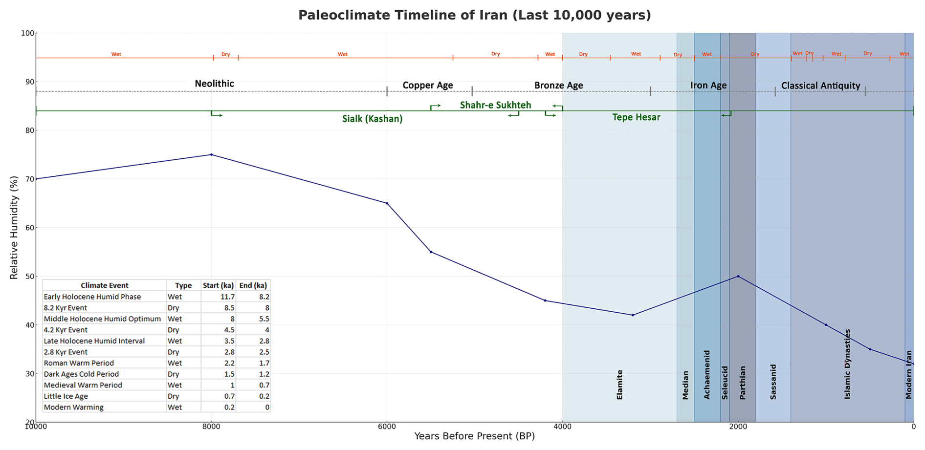
Figure 2Integrated timeline of Holocene climatic events, major historical periods in Iran, hydrological changes in PAMELA Lake, geological activity, and historical evidence. Climatic data are based on Wanner et al. (2008), Mayewski et al. (2004), and Büntgen et al. (2016); dynastic periods follow Frye (1962) and Axworthy (2007, 2008); and historical-geological evidence derives from Qazvini (1275), Persia (1888), Strange (1893), Schindler (1888), Berberian (1994), and Ambraseys and Melville (1982). More information are available in Table S1 in the Supplement.
In his travelogue concerning the deserts of Iran, Hedin (1910) provides a more comprehensive account of the characteristics of the ancient lake that once existed in this region compared to other authors. Hedin references ancient Iranian texts indicating that during the reign of Anushiravan the Sassanid (531–579 CE), the Gara Chai River flowed into the expansive Lake Saveh. He meticulously traced the remnants of the lake's shorelines to the cities of Jandagh and Torud (Fig. 1). Hedin also reveals that the city gate of Jandaq was constructed using timber from ships that traversed the Desert Sea, located between Jandagh and Torud.
In addition to Hedin's early 20th-century geographical observations, subsequent historical and geological studies have further examined the environmental transformations of the Saveh region. The following section highlights the impacts of climatic and tectonic dynamics on the hydrological evolution of Saveh Lake based on modern scientific analyses.
Historical accounts report that Saveh Lake desiccated around 570 CE due to major climatic shifts (Schindler, 1888). Modern geological studies indicate that this event was strongly influenced not only by climatic variability but also by tectonic activities and fluctuations in groundwater levels (Ambraseys and Melville, 1982; Berberian, 1994; Jarahi et al., 2025). Late 19th-century observations by Strange (1893) noted marine fossils and ancient seabed formations in the Saveh Plain, providing physical evidence for a former inland sea. Together with land-use change analyses (Lambton, 1960) and the documented impacts of prolonged droughts (Bosworth, 1976; Browne, 1893), these findings present a complex environmental history of the Saveh region over the past two millennia.
Zakariya Qazvini, in “Athar al-Bilad” and “Akhbar al-'Ibad” (Qazvini et al., 1330; Qazvini, 1275b), recounts,
In ancient times, there was a lake near Saveh that desiccated and transformed into arable land around the time of the birth of the Holy Prophet Muhammad (the last Prophet of Islam, 550–570 CE).
Likewise, Siroux (1949) postulates that Lake Saveh had desiccated by the time of the birth of the last Prophet of Islam. Eghtedari (Eghtedari, 2022) corroborates Sirouxs' assertions regarding the period of the lake's desiccation. In the book “Tariqh-e-Qomi” (Qomi, 1934), based on Okhravi and Djamal (2003), there are mentions of Lake Saveh and its desiccation. Additionally, it is reported that Lake Saveh was refilled in 1886 CE, according to a report from Sadid-o Saltaneh, an official from the late Qajar period, and this was reiterated two years later by Ein al-Dawla King (Persia, 1888).
Gabriel (1939) provides invaluable insights into the details of a lake situated in the current location of the Central Desert (Great Desert). He recounts stories depicting the desert as an expanse resembling a sea with ships, ports, and lighthouses, among other elements. Other researchers have also made references to ports known by various names such as “Barghin”, “Barjin”, “Barajin”, and “Parchin” (Pirniya and Afsar, 1991). Rajabi identifies the two cities of Jandagh and Torud as two forgotten ports in the desert (Rajabi, 2004).
4.4 Holocene Climatic Context and Its Implications for Saveh Lake Dynamics
Holocene climate variability exerted a decisive influence on the hydrological evolution and human occupation of the Central Iranian Plateau. Paleoclimatic records identify several major climate anomalies namely, the Younger Dryas (∼ 12 900–11 700 BP), the 8.2 ka cooling event (∼ 8200 BP), and the 4.2 ka aridification (∼ 4200 BP) each corresponding to marked decreases in water availability and adaptive shifts in human settlement patterns (Alley et al., 1997; Mayewski et al., 2004; Weiss et al., 1993). In contrast, the Early Holocene Humid Period (∼ 11 700–8200 BP) and the Mid-Holocene Climatic Optimum (∼ 8000–5500 BP) are characterized by increased effective moisture, promoting lacustrine expansion and cultural development (Wanner et al., 2008). Recent reconstructions by Vaezi et al. (2025), based on isotopic, palynological, and sedimentary proxies from the Halil Rud and Zeribar Lake regions, highlight the Early–Mid Holocene as a period of maximal Quaternary wetness in central Iran. This aligns temporally with the modeled peak stages of the Paleo Mega Lake of Rey (PAMELA), supporting a climatic foundation for its development and persistence.
Notably, the proposed drying phase of Saveh Lake around the 6th century CE temporally coincides with historical accounts linking the lake's disappearance to the birth of the Prophet Muhammad (circa 570 CE). This narrative, cited in early Islamic historiography, may align with broader climatic disruptions occurring during the Late Antique Little Ice Age (LALIA), dated between ∼ 536 and ∼ 660 CE (Büntgen et al., 2016). The LALIA was marked by sustained volcanic forcing, solar minima, and widespread famines across Eurasia, including the notable great famine of 570 CE. While causality cannot be directly confirmed, the synchronicity of paleohydrological regression and socioreligious historical memory suggests that the desiccation of Saveh Lake may have been part of a broader regional environmental crisis.
In addition to textual and geomorphological evidence, this study acknowledges a corpus of ethnographic interviews collected across regions such as Damghan (Rashm), Jandagh, Bam (Borouat), Qarchak, Saveh, and Kashan. In these interviews, local elders recounted ancestral memories of inland navigation and fishing practices, often transmitted across generations. While these narratives remain anecdotal and require systematic folkloristic verification, their spatial alignment with the hypothesized PAMELA basin warrants further interdisciplinary investigation.
4.5 Contextualizing PAMELA within global paleolake research
Our reconstruction of the Paleo Mega Lake of Rey (PAMELA) not only provides new insights into the hydrological and cultural history of central Iran but also contributes to broader debates on the role of pluvial basins in shaping human–environment interactions. Similar to the Great Basin lakes of North America (Reheis et al., 2014), Mega-Lake Chad in Africa (Armitage et al., 2015; Li et al., 2023), and the Altiplano lakes of South America (Placzek et al., 2006), PAMELA illustrates how closed-basin hydrosystems can expand dramatically in response to climatic oscillations and then contract, leaving behind enduring geomorphic and cultural legacies. By situating Iranian evidence within this comparative framework, the study highlights both the methodological portability of our approach and the importance of Iran as a climatic crossroads between the Mediterranean Westerlies and the Indian Summer Monsoon.
This study, grounded in a robust interdisciplinary framework encompassing textual historiography, sedimentology, and paleoclimatology, reconstructs the probable existence of an extensive inland lake system across central Iran, hereafter referred to as the Paleo Mega Lake of Rey (PAMELA). Geological correlations and historical cross-referencing suggest that this pluvial system may have originated during the terminal Pleistocene and expanded across the Rey–Dasht-e Lut corridor throughout much of the Holocene.
The confluence of Zoroastrian cosmogonic descriptions, Sassanid and Islamic-era geographies, and modern observational reports with present-day digital topography delineates a hydrological continuum with far-reaching impacts on regional settlement patterns, land use, and cultural memory.
It should be noted that the scattered sedimentological datasets obtained from basins such as Jazmurian and Hamoun may, in fact, represent fragments of a larger paleo-lacustrine puzzle namely, the PAMELA system. Although these records have been independently analyzed within their respective local contexts, their cumulative implications strongly and implicitly affirm the existence of a unified and extensive lake structure.
From a paleoclimatic perspective, the synchrony between elevated Holocene effective moisture intervals and the expansion of this basin, alongside the abrupt regressions associated with the 4.2 ka aridification event, further substantiate the lake's temporal dynamics. This study not only strengthens the empirical foundations of PAMELA's hypothesis but also signals the necessity of revisiting Central Iran's environmental and civilizational narratives. Future investigations should prioritize stratigraphic coring, radiometric dating, and high-resolution terrain modeling to derive a definitive reconstruction of the PAMELA system.
No custom or proprietary software code was developed for this study. All spatial analyses and cartographic products, including Fig. 1, were generated using the publicly accessible ArcGIS Pro platform (version 3.1; Esri, Redlands, CA, USA). The software is commercial and licensed, and therefore its source code is not openly accessible. Only standard built-in geoprocessing tools and visualization modules were used, and no user-written scripts were created. Documentation and metadata for ArcGIS Pro functionalities are publicly available through Esri (2024, https://pro.arcgis.com/, last access: 30 October 2025).
All datasets used in this study are publicly accessible. The digital elevation data (ALOS-PALSAR, 12.5 m resolution) were obtained from the Alaska Satellite Facility (ASF) and can be freely downloaded upon registration: ASF (2024, https://search.asf.alaska.edu/, last access: 30 October 2025) and USGS (2024, https://earthexplorer.usgs.gov/, last access: 30 October 2025).
The historical textual sources used in this research are cited individually in the reference list and are available through published archival and scholarly repositories. No proprietary or unpublished datasets were generated as part of this study. All spatial outputs produced in the GIS workflow are fully described within the manuscript.
The supplement related to this article is available online at https://doi.org/10.5194/hgss-16-41-2025-supplement.
HJ: formal analysis, fieldwork, methodology; DN: investigation, and writing the manuscript.
The contact author has declared that neither of the authors has any competing interests.
Publisher's note: Copernicus Publications remains neutral with regard to jurisdictional claims made in the text, published maps, institutional affiliations, or any other geographical representation in this paper. While Copernicus Publications makes every effort to include appropriate place names, the final responsibility lies with the authors. Views expressed in the text are those of the authors and do not necessarily reflect the views of the publisher.
At the end of this research, I (Hadi Jarahi) would like to honor the memory of my beloved late mother, whose love, patience, and blessings remain deeply woven into every part of my life. She taught me how to stand strong in the face of hardships and how to be kind to others. I dedicate these words to her memory, hoping her noble soul rests in eternal peace.
I am grateful to Dr. Saeed Oryan at Tehran University is appreciated for his valuable advice and guidance in locating the names of his book.
This paper was edited by Maurits Ertsen and reviewed by Mohsen Pourkermani and Saed Moghimi.
Afshar, I.: New History of Yazd, 2nd edn., Publications of Farhang-e Iran Zamin, Tehran, Iran, 320 pp., ISBN 9789644456701, 1978 (in Persian).
Alley, R. B., Mayewski, P. A., Sowers, T., Stuiver, M., Taylor, K. C., and Clark, P. U.: Holocene climatic instability: A prominent, widespread event 8200 yr ago, Geology, 25, 483–486, 1997.
Ambraseys, N. N. and Melville, C. P.: A History of Persian Earthquakes, Cambridge University Press, Cambridge, vol. 1, 219, ISBN 9780521021876, ISBN 0521021871, 1982.
Armitage, S. J., Bristow, C. S., and Drake, N. A.: West African monsoon dynamics inferred from abrupt fluctuations of Lake Mega-Chad, Proceedings of the National Academy of Sciences, 112, 8543–8548, 2015.
ASF: ALOS PALSAR Digital Elevation Model [data set], https://search.asf.alaska.edu/ (last access: 30 October 2025), 2024.
Axworthy, M.: Empire of the Mind: A History of Iran, Hurst, 333 pp., ISBN 9781850658719, ISBN 1850658714, 2007.
Axworthy, M.: Iran: Empire of the mind: A history from Zoroaster to the present day, Penguin UK, ISBN 7513932905 ISBN 9787513932905, 2008.
Baran, Z. J. and Cardenas, B. T.: Modeling Lake Bonneville paleoshoreline erosion at Mars-like rates and durations: Implications for the preservation of erosional Martian shorelines and viability as evidence for a Martian ocean, Journal of Geophysical Research: Planets, 130, e2024JE008851, https://doi.org/10.1029/2024JE008851, 2025.
Berberian, M.: Natural hazards and the first earthquake catalogue of Iran, vol. 1, International Institute of Earthquake Engineers and Seismology, 603 pp., https://www.google.com/books/edition/Natural_Hazards_and_the_First_Earthquake/TKwwswEACAAJ (last access: 30 October 2025), 1994.
Berberian, M.: Earthquake and Coseismic Surface Faulting on the Iranian Plateau; a Historical, Social, and Physical Approach, 1st edn., Elsevier, 770 pp., ISBN 9780444632920, 2014.
Berberian, M. and Yeats, R. S.: Tehran: An Earthquake Time Bomb; In Tectonic Evolution, Collision, and Seismicity of Southwest Asia: In Honor of Manuel Berberian's Forty-Five Years of Research Contributions, The Geological Society of America, 1, 84, https://doi.org/10.1130/2016.2525(04), 2016.
Bivar, A. D. H.: The political history of Iran under the Arsacids, Cambridge History of Iran, 3, 21–99, https://doi.org/10.1017/CHOL9780521200929.004, 1983.
Bosworth, C. E.: The City Walls of Sāva (ancient Sāwah) and Their Date. Iran, 14, 69–74, https://doi.org/10.2307/4299753, 1976.
Briant, P.: From Cyrus to Alexander: a history of the Persian Empire, Penn State Press, https://doi.org/10.5325/j.ctv1bxgwdk, 2002.
Browne, E. G.: A Year Amongst the Persians: Impressions as to the Life, Character & Thought of the People of Persia, A., and C. Black Publishers, London, 594 pp., https://www.google.com/books/edition/A_Year_Amongst_the_Persians/GM0oAAAAYAAJ (last access: 30 October 2025), 1893.
Büntgen, U., Myglan, V. S., Ljungqvist, F. C., McCormick, M., Di Cosmo, N., Sigl, M., Jungclaus, J., Wagner, S., Krusic, P. J., and Esper, J.: Cooling and societal change during the Late Antique Little Ice Age from 536 to around 660 AD, Nature Geoscience, 9, 231–236, 2016.
Chen, C. Y. and Maloof, A. C.: Revisiting the deformed high shoreline of Lake Bonneville, Quaternary Science Reviews, 159, 169–189, 2017.
Curtis, J.: Ancient Persia, British Museum, Harvard University Press, 72 pp., ISBN 9780674034150, 1990.
Djamali, M., Gondet, S., Ashjari, J., Aubert, C., Brisset, E., Longerey, J., Marriner, N., Mashkour, M., Miller, N. F., and Naderi-Beni, A.: Karstic spring wetlands of the Persepolis Basin, southwest Iran: unique sediment archives of Holocene environmental change and human impacts, Canadian Journal of Earth Sciences, 55, 1158–1172, 2018.
Dyson, R. H. and Howard, S. M.: Tappeh Hesār: Reports of the Restudy Project, 1976, Casa editrice Le Lettere, https://ehrafarchaeology.yale.edu/traditions/ma50/documents/003 (last access: 30 October 2025), 1989.
Eghtedari, A.: Sadid Alsaltaneh Travel Book, 2nd edn., Sokhan, Tehran, Iran, 739 pp., ISBN 9789651249914, 2022 (in Persian).
Emmerick, R. E. and Macuch, M.: The Literature of Pre-Islamic Iran: Companion Volume I, Bloomsbury Academic, 448 pp., ISBN 9780857736536, 2008.
Esri: ArcGIS Pro 3.1, Esri Inc., https://pro.arcgis.com/ (last access: 30 October 2025), 2024.
Fornari, M., Risacher, F., and Féraud, G.: Dating of paleolakes in the central Altiplano of Bolivia, Palaeogeography, Palaeoclimatology, Palaeoecology, 172, 269–282, 2001.
Frye, R. N.: The Heritage of Persia, World Publishing Company, Cleveland, 514 pp., ISBN 9780451606624, ISBN 0451606620, 1962.
Gabriel, A.: Aus den Einsamkeiten Irans, 1st edn., Strecker und Schroder Verlag, Stuttgart, Germany, 186 pp., https://www.cambridge.org/core/journals/geological-magazine /article/abs/aus-den-einsamkeiten-irans-by-gabriel-alfons-pp-xv-186-65-illustrations-2-maps-stuttgart-strecker-u-schrader-1939-rm-9/513DADB86F1EB910C3A439F5429988B0 (last access: 30 October 2025), 1939.
Ghienne, J.-F., Schuster, M., Bernard, A., Duringer, P., and Brunet, M.: The Holocene giant Lake Chad revealed by digital elevation models, Quaternary International, 87, 81–85, 2002.
Haghighat, A.: The History of Semnan, 1st edn., Etelaat Publication, Tehran, Iran, 236 pp., ISBN 978-964-246-219-3, 1962 (in Persian).
Hamzeh, M. A., Mahmudy-Gharaie, M. H., Alizadeh-Lahijani, H., Moussavi-Harami, R., Djamali, M., and Naderi-Beni, A.: Paleolimnology of Lake Hamoun (E Iran): Implication for past climate changes and possible impacts on human settlements, Palaios, 31, 616–629, 2016.
Hedin, S. A.: Overland to India, F. Edition, Macmillan and Company, limited, 772 pp., https://www.google.com/books/edition/Overland_to_India/dDGrxQEACAAJ (last access: 30 October 2025), 1910.
Hintze, A.: Avestan Literature, in: The Literature of Pre-Islamic Iran: Companion Volume I, edited by: Yarshater, E., I.B. Tauris in association with The Ehsan Yarshater Center for Iranian Studies, Vol. 1, Columbia University, London & New York, ISBN 978-1-84511-887-7, 2009.
Jarahi, H.: Paleo Mega Lake of Rey Identification and Reconstruction of Quaternary Lake in Central Iran, Open Quaternary, 7, 1–15, https://doi.org/10.5334/oq.94, 2021.
Jarahi, H., Abdollahi, M., Aboutalebi, H., and Khosronezhad, A.: Investigating the effects of active tectonics on rockfall susceptibility along the mountain sector of Chalus Highway, Pure and Applied Geophysics, 10, https://doi.org/10.1007/s00024-025-03765-4, 2025.
Kakroodi, A., Leroy, S., Kroonenberg, S., Lahijani, H., Alimohammadian, H., Boomer, I., and Goorabi, A.: Late Pleistocene and Holocene sea-level change and coastal paleoenvironment evolution along the Iranian Caspian shore, Marine Geology, 361, 111–125, 2015.
Kateb, A. E. H. E. A.: History of Yazd, 1st edn., Publications of Farhang-e Iran Zamin, Tehran, Iran, 328 pp., https://ketabnak.com/reader/114213 (last access: 30 October 2025), 1458 (in Persian).
Krinsley, D. B.: A Geomorphological and Paleoclimatological Study of the Playas of Iran, Air Force Cambridge Research Labs, https://www.google.com/books/edition/Geomorphological_and_Paleoclimatological/4TJHJjl-RIQC (last access: 30 October 2025), 1970.
Lambton, A. K. S.: Landlord and Peasant in Persia: A Study of Land Tenure and Land Revenue Administration, University of California Press, Berkeley, 410 pp., https://www.google.com/books/edition/Landlord_and_Peasant_in_Persia/ichfAAAAIAAJ (last access: 30 October 2025), 1960.
Li, Y., Kino, K., Cauquoin, A., and Oki, T.: Contribution of lakes in sustaining the Sahara greening during the mid-Holocene, Clim. Past, 19, 1891–1904, https://doi.org/10.5194/cp-19-1891-2023, 2023.
Mayewski, P. A., Rohling, E. E., Curt Stager, J., Karlén, W., Maasch, K. A., David Meeker, L., Meyerson, E. A., Gasse, F., van Kreveld, S., Holmgren, K., Lee-Thorp, J., Rosqvist, G., Rack, F., Staubwasser, M., Schneider, R. R., and Steig, E. J.: Holocene climate variability, Quaternary Research, 62, 243–255, https://doi.org/10.1016/j.yqres.2004.07.001, 2004.
Naderi Beni, A., Lahijani, H., Mousavi Harami, R., Arpe, K., Leroy, S. A. G., Marriner, N., Berberian, M., Andrieu-Ponel, V., Djamali, M., Mahboubi, A., and Reimer, P. J.: Caspian sea-level changes during the last millennium: historical and geological evidence from the south Caspian Sea, Clim. Past, 9, 1645–1665, https://doi.org/10.5194/cp-9-1645-2013, 2013.
Namdar, D., Jarahi, H., and Maghami Moghim, G.: Introduction to Hecatompylos Lake in Damghan, in: 17th Conference of the Iranian Paleontological Society, Hormozgan University, p. 8, https://www.researchgate.net/publication/388763751_Introduction_to_Hecatompylos_Lake_in_Damghan (last access: 30 October 2025), 2025a (in Persian).
Namdar, D., Jarahi, H., and Maghami Moghim, G.: Paleo Mega Lake of Rey, An Introduction to Water Level-Volume Changes Over Time from a Morphological Perspective, in: 7th International Conference of Biology and Earth Science, Hamadan, 1–9, https://civilica.com/doc/2212764/ (last access: 30 October 2025), 2025b.
Namdar, D., Jarahi, H., and Maghami Moghim, G.: Paleo Mega Lake of Rey, North Yazd Paleoshoreline Sedimentology, in: 9th Symposium of Sedimentological Society of Iran, Tabas, 1–10, https://civilica.com/doc/2212764 (last access: 30 October 2025),, 2025c.
Nazari, H., Ritz, J.-F., Salamati, R., Shahidi, A., Habibi, H., Ghorashi, M., and Karimi Bavanpur, A.: Distinguishing between fault scarps and shorelines: the question of the nature of the Kahrizak, North Rey and South Rey features in the Tehran plain (Iran), Terra Nova, 22, 227–237, 2010.
Okhravi, R. and Djamali, M.: The missing ancient Lake of Saveh; a historical review, T. Iranica Antiqua, 38, 327–344, 2003.
Oryan, S.: Bundahishn, Transcription, translation, notes based on the version number (1) of Tammors Dinshah TD1, 1st edn., Vol. 1., Barsam, Tehran, 670 pp., ISBN 9786229618158, 2021 (in Persian).
Persia, S. O.: On the New Lake between Kom and Teherân, Proceedings of the Royal Geographical Society and Monthly Record of Geography, 10, 624–632, https://doi.org/10.2307/1800849, 1888.
Pirniya, K. and Afsar, K.: Road and Robats, National Antiquities Protection Organization of Iran, Tehran, Iran, 220 pp., https://www.google.com/books/edition/%D8%B1%D8%A7%D9%87_%D9%88_%D8%B1%D8%A8%D8%A7%D8%B7/8gNGAQAAIAAJ (last access: 30 October 2025), 1991 (in Persian).
Placzek, C., Patchett, P. J., Quade, J., and Wagner, J. D.: Strategies for successful U-Th dating of paleolake carbonates: An example from the Bolivian Altiplano, Geochemistry, Geophysics, Geosystems, 7, https://doi.org/10.1029/2005GC001157, 2006.
Potts, D. T.: The archaeology of Elam: formation and transformation of an ancient Iranian state, Cambridge University Press, https://doi.org/10.1017/CBO9780511489617, 2016.
Pourali, M., Sepehr, A., Hosseini, Z., and Hamzeh, M. A.: Sedimentology, geochemistry, and geomorphology of a dry-lake playa, NE Iran: implications for paleoenvironment, Carbonates and Evaporites, 38, p. 9, https://doi.org/10.1007/s13146-022-00829-7, 2023.
Pourdavoud, E.: Yasht's. The Avesta, 1st edn., vol. 1, Asatir, Tehran, Iran, 626 pp., ISBN 978-6003760394, 2015 (in Persian).
Qazvini, F. H. A. M., Browne, E. G., and Nicholson, R. A.: The Ta'ríkh-I-Guzída; Or, Select History of Hamdulláh Mustawfí-I-Qazwíní, compiled in A.H. 730 (A.D. 1330), and Now Reproduced in Fac-Simile from a Ma, Creative Media Partners, LLC, 556 pp., https://www.rarewaves.com/products/9781019319499-the-tarikh-i-guzida-or-select-history-of-hamdullah-mustawfi- i-qazwini-compiled-in-ah-730-ad-1330-and-now-reproduced-in-fac-simile-from-a-manuscript-dated-ah-857-ad-1453 (last access: 30 October 2025), 1330.
Qazvini, Z. M.: Āthār al-Bilād wa-Akhbār al-Ībād, 600 pp., ISBN 9786447069183, ISBN 6447069182, 1275 (in Arabic).
Qomi, H. A. and Qomi, H. M.: Tarix-I Qum, vol. 1, Tus, Tehran, 400 pp., https://www.google.com/books/edition/%D9%83%D8%AA%D8%A7%D8%A8_%D8%AA%D8%A7%D8%B1%D9%8A%D8%AE_%D9%82%D9%85/W4ExvDXNyKkC?hl=en&gbpv=0&bsq=%D8%AA%D8%A7%D8%B1%DB%8C%D8%AE%20%D9%82%D9%85%DB%8C (last access: 30 October 2025), 1934 (in Persian).
Qomi, S. D. M. M. H. H.: Tarix-I Qum, vol. 1, Tus, Tehran, 874 pp., ISBN 9789648179446, ISBN 9648179441, 1934 (in Persian).
Rajabi, P.: Jandagh and Trudeau: Two forgotten ports of the Great Salt Desert, vol. 1, Pezhvak Keyvan, Iran, 142 pp., ISBN 9789649490533, 2004 (in Persian).
Reheis, M. C., Adams, K. D., Oviatt, C. G., and Bacon, S. N.: Pluvial lakes in the Great Basin of the western United States – a view from the outcrop, Quaternary Science Reviews, 97, 33–57, 2014.
Rieben, E. H.: Geological observations on alluvial deposits in northern Iran, Geol. Survey. Iran, 9, 39, https://www.google.com/books/edition/Geological_Observations_on_Alluvial_Depo/4VVPAQAAIAAJ (last access: 30 October 2025), 1966.
Schindler, A.: Reisen in Persien: Erlebnisse und Beobachtungen aus den Jahren 1870–1885, Justus Perthes Verlag, Gotha, Germany, 488 pp., ISBN 9786001658778, 1888.
Shoaee, M. J., Breeze, P. S., Drake, N. A., Hashemi, S. M., Nasab, H. V., Breitenbach, S. F., Stevens, T., Boivin, N., and Petraglia, M. D.: Defining paleoclimatic routes and opportunities for hominin dispersals across Iran, PLoS One, 18, e0281872, https://doi.org/10.1371/journal.pone.0281872, 2023.
Siroux, M.: Caravansérails d'Iran et petites constructions routière, Institut Français d'Archéologie Orientale, 600 pp., https://www.google.com/books/edition/Caravansérails_d_Iran_et_petites_constr/bpMjSAAACAAJ (last access: 30 October 2025), 1949 (in French).
Strange, G. L.: The Lands of the Eastern Caliphate: Mesopotamia, Persia, and Central Asia, from the Moslem Conquest to the Time of Timur, Cambridge University Press, 580 pp., https://www.google.com/books/edition/The_Lands_of_the_Eastern_Caliphate/-vOf7uE1APYC (last access: 30 October 2025), 1893.
Strange, G. L.: The Lands of the Eastern Caliphate: Mesopotamia, Persia, and Central Asia, from the Moslem Conquest to the Time of Timur, University Press, 592 pp., https://doi.org/10.1017/S0003598X00005792, 1930.
USGS: Landsat-8 OLI/TIRS Collection [data set], https://earthexplorer.usgs.gov/ (last access: 30 October 2025), 2024.
Vaezi, A., Ghazban, F., Tavakoli, V., Routh, J., Beni, A. N., Bianchi, T. S., Curtis, J. H., and Kylin, H.: A Late Pleistocene-Holocene multi-proxy record of climate variability in the Jazmurian playa, southeastern Iran, Palaeogeography, Palaeoclimatology, Palaeoecology, 514, 754–767, 2019.
Vaezi, A., Djamali, M., Tavakoli, V., and Naderi Beni, A.: Paleoenvironmental and Paleoclimatic Changes and their Reciprocal Effects on Ancient Settlements in Southern Iran, with a Focus on the Halil Rud Cultural Zone, from 4000 to 2900 Years Ago, Pazhoheshha-ye Bastan shenasi Iran, 14, 37–63, https://doi.org/10.22084/nb.2023.26444.2501, 2025.
Wanner, H., Beer, J., Bütikofer, J., Crowley, T. J., Cubasch, U., Flückiger, J., Goosse, H., Grosjean, M., Joos, F., and Kaplan, J. O.: Mid-to Late Holocene climate change: an overview, Quaternary Science Reviews, 27, 1791–1828, 2008.
Weiss, H., Courty, M.-A., Wetterstrom, W., Guichard, F., Senior, L., Meadow, R., and Curnow, A.: The genesis and collapse of third millennium north Mesopotamian civilization, Science, 261, 995–1004, 1993.