the Creative Commons Attribution 4.0 License.
the Creative Commons Attribution 4.0 License.
 | 09 Nov 2021
The bicentenary of Georg Hartung, a German pioneer geologist, explorer, and illustrator
Carlos A. Góis-Marques
Miguel Menezes de Sequeira
José Madeira
We present a tribute to Georg Friedrich Karl Hartung (1821–1891), a less-known, non-academic German geologist, on his 200th birthday anniversary. Influenced by eminent 19th century scientific personalities, such as Oswald Heer, Charles Lyell, and Alexander von Humboldt, he performed pioneer geological observations and sampling in the Azores, Madeira, and Canary Islands volcanic archipelagos. Later in his life, he travelled to the USA and explored the Scandinavian countries. His scientific endeavours were published in several books and papers, many of them co-authored by academic German geologists and palaeontologists. His works on Macaronesia are deemed as classics, and many have been enriched by his detailed geological illustrations.
- Article
(12686 KB) - Full-text XML
- BibTeX
- EndNote


Georg(e) Friedrich Karl Hartung, or Georg Hartung, was born on 13 July 1821 in Königsberg (then Prussia, now Kaliningrad, Russia), and died in Heidelberg (Germany) on 28 March 1891 (e.g. Bouheiry, 2015; Lindemann, 1891; Pinto and Bouheiry, 2007). He was born into a well-established and wealthy family, and his father owned a printing and a publishing company, which was responsible for the publication of the journal called Hartungsche Zeitung (Bouheiry, 2015). To date, no known portrait is available of Hartung (Pinto and Bouheiry, 2007; Annete Bouheiry, personal communication, 2021), although he represents himself in his geological drawings as taking notes or sketching (Fig. 1a) or talking to local people (Fig. 1b). Hartung's signature (Fig. 2), was found within an unpublished manuscript (see Lyell, 1854/1855) in a partial and undated letter to Charles Lyell (1797–1875).
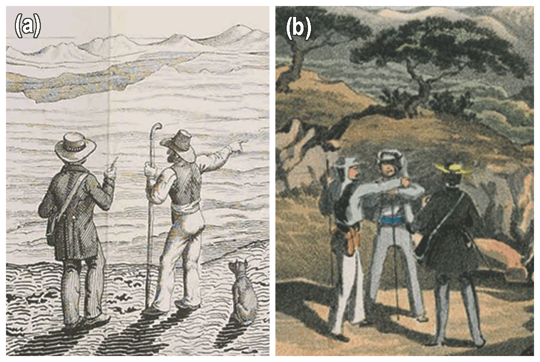
Figure 1Details of two illustrations depicting Georg Hartung performing fieldwork. (a) Hartung (left figure with a hat) taking notes from his guide on Fuerteventura, Canary Islands (extracted from plate III in Hartung, 1857b; https://www.biodiversitylibrary.org/item/46730#page/320/mode/1up, last access: 26 September 2021). (b) The same person on São Miguel Island (Azores archipelago) talking with the locals (extracted from plate VII in Hartung, 1860a; https://www.e-rara.ch/zut/content/zoom/7111419, last access: 26 September 2021). Both images are public domain.
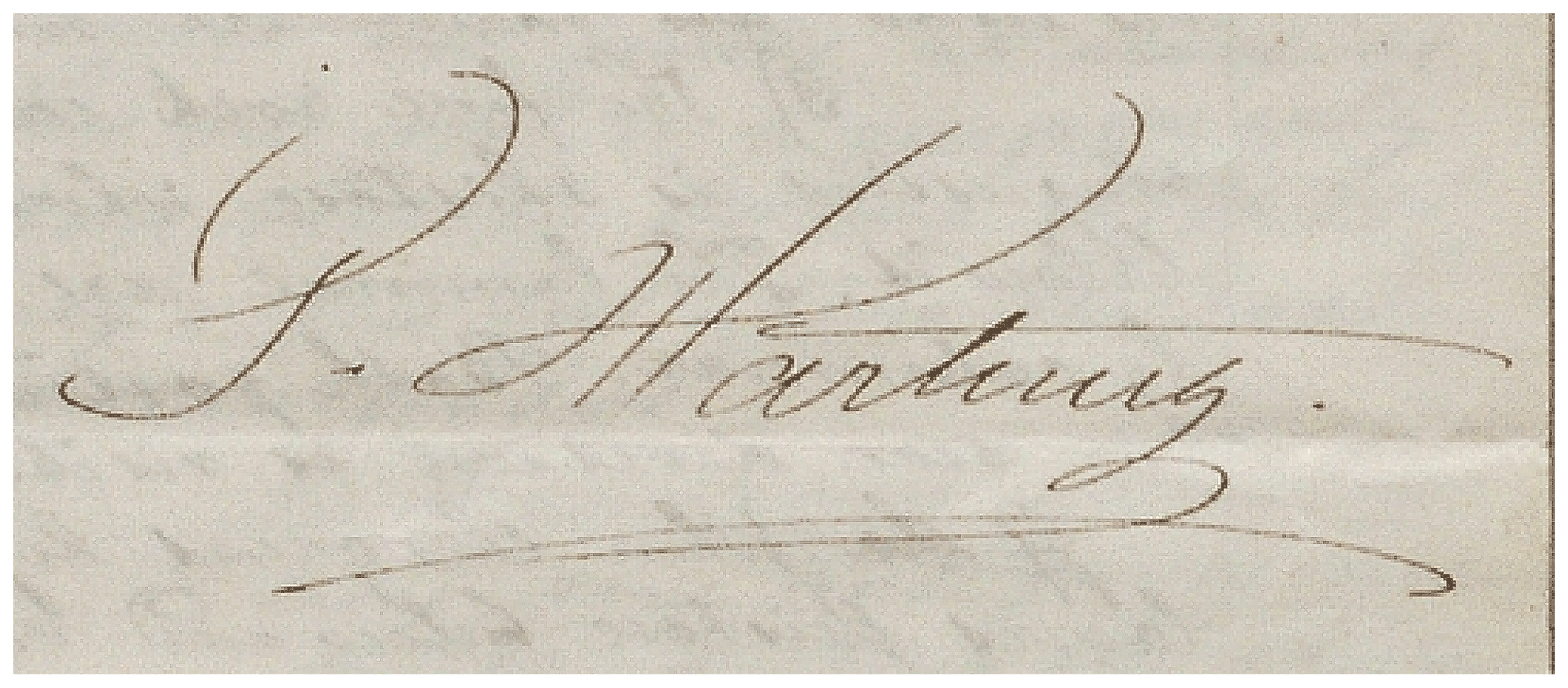
Figure 2The signature of Georg Hartung found, in a partial letter addressed to Lyell, within Lyell's manuscript dealing with Madeira (see Lyell, 1854/1855). Image courtesy of the University of Edinburgh Library, under Creative Commons – attribution CCBY 4.0 International.
Most information about Hartung comes from his own work or his correspondence (Pinto and Bouheiry, 2007; Bouheiry, 2013, 2015; Sarmiento Pérez, 2004). Hartung received a degree in Agronomy (1841–1843; University of Greifswald; Bouheiry, 2015). Lacking a formal geological education, in 1855 he took private geology lessons with Gustav von Leonhard (1816–1878; e.g. Pinto and Bouheiry, 2007; Bouheiry, 2013), and in 1862, he received an honorary doctorate from the University of Königsberg, most probably due to his geological work on the Atlantic islands (Reifs, 1891; Bouheiry, 2015, 2013). Moreover, he was a gifted illustrator, considering his geological sketches (see Figs. 3 to 8).
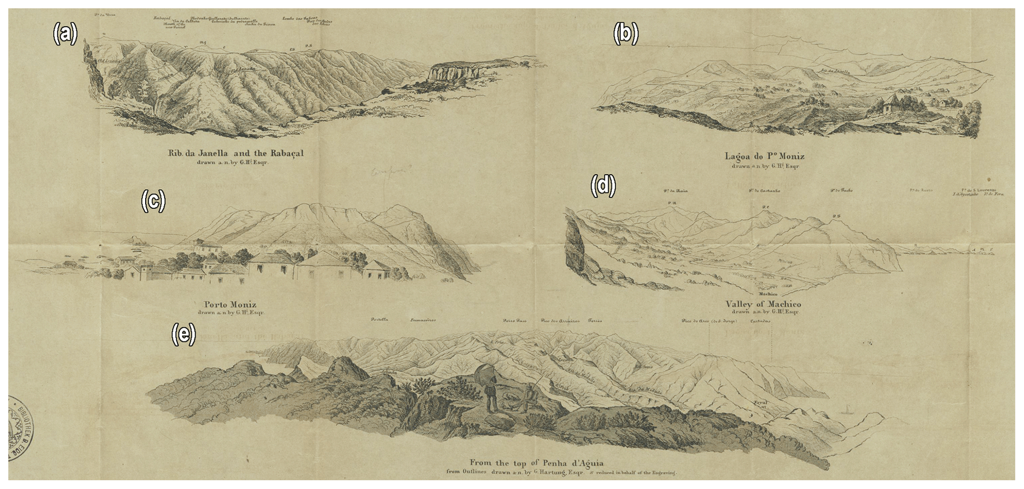
Figure 3Panoramic views drawn by Georg Hartung printed on the back of the Ziegler et al. (1856) physical map of Madeira. (a) The Ribeira da Janela stream and Rabaçal locality. (b) The Lagoa do Fanal locality in Porto Moniz. (c) Porto Moniz village. (d) Machico and Ponta de São Lourenço in the eastern part of the island. (e) View from the of top Penha d'Águia (Porto da Cruz), showing the central part of the island. Note that the depicted persons are probably Hartung, holding an umbrella while sketching, and his local guide waiting for him. The image is public domain and was digitalized by ETH-Bibliothek Zurich (https://doi.org/10.3931/e-rara-38937, last access: 26 September 2021).
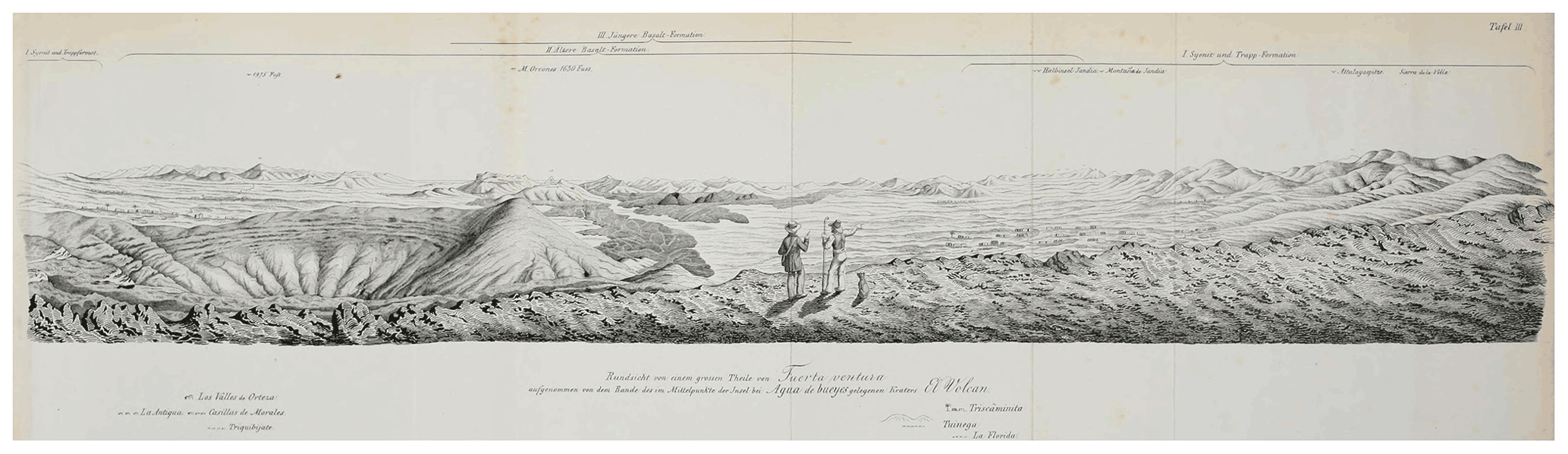
Figure 4Hartung (1857b), plate III, depicting a panoramic view of Fuerteventura (Canary Islands) from the locality of Agua de Bueyes. The image is public domain and was digitalized by the Biodiversity Heritage Library (https://www.biodiversitylibrary.org/item/46730#page/320/mode/1up, last access: 26 September 2021).
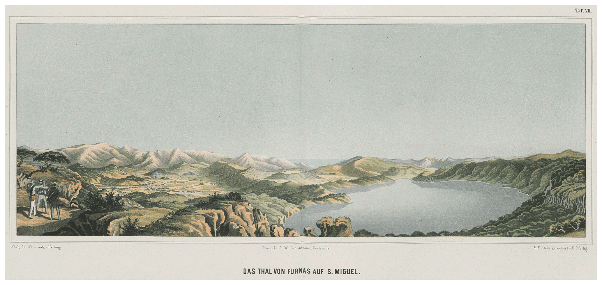
Figure 5Hartung (1860a), plate VII, depicting a panoramic view of Furnas in São Miguel Island. The image is public domain and was digitalized by ETH-Bibliothek Zurich (https://www.e-rara.ch/zut/content/zoom/7111419, last access: 26 September 2021).
In the winter of 1850–1851, suffering from catarrh, Hartung travelled to Madeira (Portugal) to seek a milder climate to ameliorate his poor health (Pinto and Bouheiry, 2007). In Funchal, he met the Swiss palaeobotanist Oswald Heer (1809–1883), who travelled to Madeira due to similar health problems (e.g. Schröter and Heer, 1885; Bouheiry, 2013). During this stay, Hartung accompanied Heer on his fieldwork (Heer, 1857; Schröter and Heer, 1885). Heer influenced Hartung to start studying the geology of Madeira (Bouheiry, 2013). Hartung returned to Madeira in the following winter (1851–1852), also travelling to Porto Santo (Madeira archipelago) and Tenerife (Canary Island archipelago), to make geological observations (Bouheiry, 2013). On his return to Madeira in the winter of 1853–1854, he met the English geologist Charles Lyell (1797–1875), who had travelled to Madeira to study the geology of the Atlantic islands. According to Wilson (2007), Lyell went to Madeira to evaluate the catastrophist theory of the craters of elevation postulated by Leopold von Buch (1774–1853; Buch, 1826), which went against his uniformitarian views (Lyell, 1855). Lyell choose Hartung to accompany him due to his geological curiosity and knowledge of the Portuguese language and the geography of the island. Both travelled to Madeira and to the Canary Islands of Tenerife, La Palma, and Gran Canaria (Pinto and Bouheiry, 2007; Wilson, 2007). In the winter of 1854, Hartung proceeded alone to explore the Canary Islands of Lanzarote and Fuerteventura (Bouheiry, 2015).
Hartung planned to publish the geological observations of Madeira and the Canary Island archipelagos with Lyell, but, due to Lyell's schedule, this never came to fruition (Bouheiry, 2013), although a manuscript draft by Lyell with several sketches and illustrations by Hartung does exist (see Lyell and Hartung, 1856, unpublished manuscript). In 1856, during a meeting with scholars in Berlin that included Lyell, Hartung was encouraged by Alexander von Humboldt (1769–1859) to travel and study the geology of the Azores archipelago (Bouheiry, 2015, 2013), and he, in fact, travelled to the Azores archipelago in 1857. During his stay in the Azores, he produced a manuscript (Hartung, 1857a) on the geology of Terceira Island (see Pinto, 2007). Hartung's exploration in the Azores is mentioned in Charles Darwin's (1809–1882) letters to Joseph Dalton Hooker (1817–1911) and to Lyell (Darwin Correspondence Project, 2021a–d). The geological data reported to Darwin were included in the first edition of On the Origin of Species (see Darwin, 1859, p. 363).
Having explored the archipelagos of Madeira, the Canary Islands and the Azores, Hartung proceeded, in 1858 to 1861, to explore the volcanic areas of Germany to compare them with his own observations in the Atlantic islands (Bouheiry, 2015). He started to publish his results and illustrations on Lanzarote and Fuerteventura (Hartung and Arlett, 1858; Hartung, 1857b; Fig. 3), on the Azores (Hartung, 1860a, b; Figs. 4 and 5), and on Gran Canaria (Hartung, 1862). Hartung further published his observations on Madeira and the Porto Santo Island (Hartung and Mayer, 1864; Figs. 6 and 7), and was co-author of a book about the geology of Tenerife (Fritsch et al., 1867; Fig. 8), with these being the last known drawings he published. However, in 1870, Hartung was still drawing as he sent drawings to Heer depicting the Niagara Falls and the village of Matt in Switzerland (see Bouheiry, 2013).

Figure 6Hartung (1860a), plate XI, depicting geological sketches of Graciosa Island of the Azores archipelago. (a) NW–SE cross section of the island depicting the four main volcanic formations proposed by Hartung. (b) SW–NE cross section of the island. (c) SW–NE cross section of the southern part of the island, crossing the caldera of Graciosa. (d) A panorama of the caldera of Graciosa. (e) NE–SW cross section of the Graciosa caldera, signalling the Furnas do Enxofre (“hölhe” in the original). The image is public domain and was digitalized by ETH-Bibliothek Zurich (https://www.e-rara.ch/zut/content/zoom/7111423, last access: 26 September 2021).
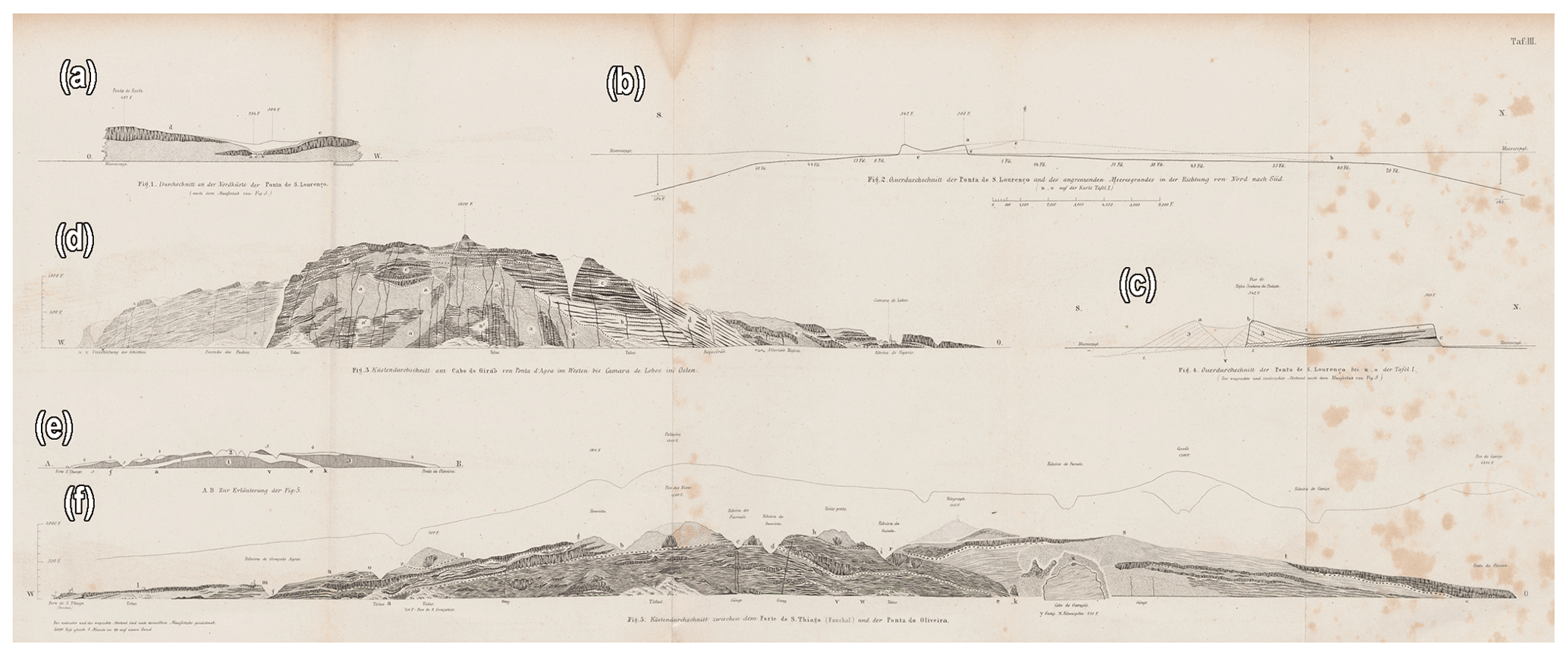
Figure 7Hartung and Mayer (1864), plate III, portraying geological sketches of Madeira and the Madeira archipelago. (a, b, c) Sketches from the eastern part of Madeira at the Ponta de São Lourenço. (a) A section of the north cliff depicting the lithology. (b) N–S cross section. (c) More details of the cross section in (b), including a stratigraphy and a reconstruction of the sea-eroded pyroclastic cone of Senhora da Piedade. (d, e, f) Drawings of the southern coast of Madeira. (d) Sea cliff from Cabo Girão to Câmara de Lobos. (e) Stratigraphy of the sea cliff portrayed in (f). (f) Sea cliff from Forte de São Tiago (Funchal) to Ponta da Oliveira (Caniço). The image is public domain and was digitalized by ETH-Bibliothek Zurich (https://www.e-rara.ch/zut/content/zoom/7222170, last access: 26 September 2021).
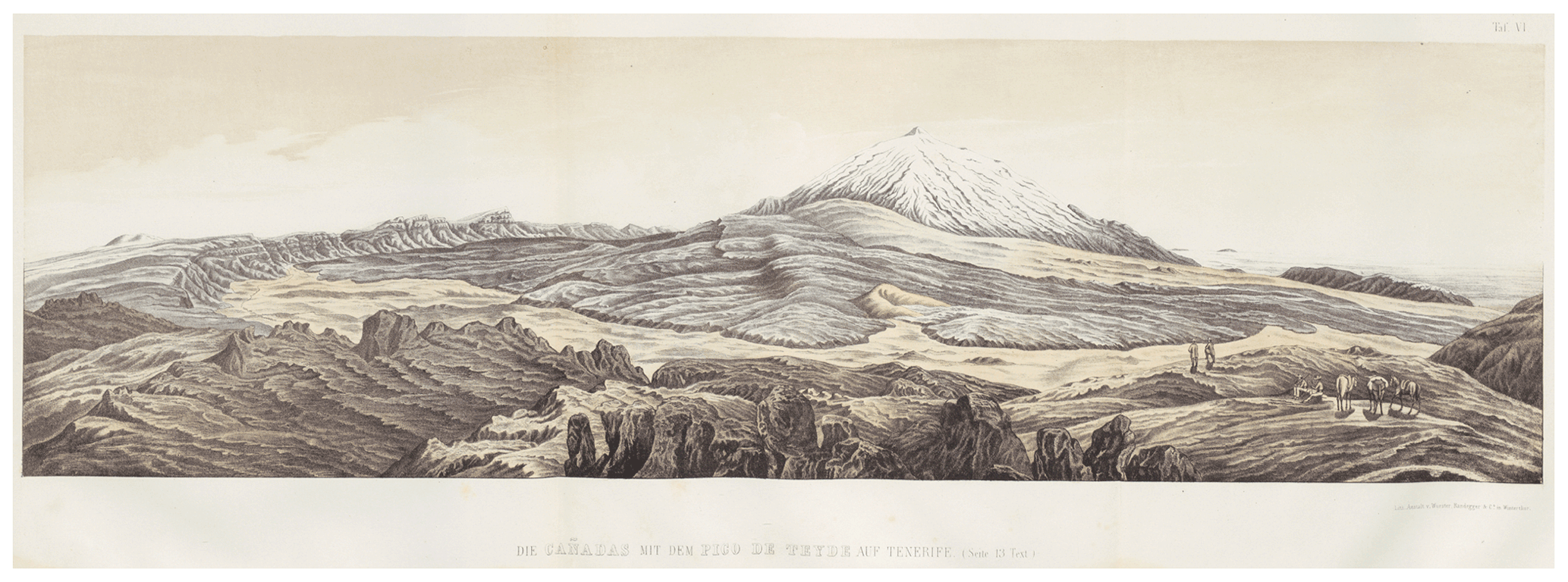
Figure 8A Hartung drawing in Fritsch (1867), plate VI, portraying a view from Las Cañadas into the Mount Teide stratovolcano in Tenerife, Canary Islands. A similar drawing was published in Lyell (1855, p. 514; Fig. 651), where credit is given to Georg Hartung. The image is public domain and was digitalized by ETH-Bibliothek Zurich (https://www.e-rara.ch/zut/content/zoom/6096244, last access: 26 September 2021).
Between 1870 and 1871, corresponding to the war between France and Germany, Hartung travelled to the United States of America, where he met Louis Agassiz (1807–1873) at Cambridge, Massachusetts (Bouheiry, 2015). Reports of this journey were published in his home journal (Hartungsche Zeitung; Bouheiry, 2015). In 1873, he changed his research focus and travelled to Sweden, leading him to further explore the Scandinavian countries (Bouheiry, 2013, 2015). The results of these explorations were published in three books (Hartung and Dulk, 1877; Hartung, 1877a, 1882) and in a report on plant fossils (Hartung, 1877b). The last known writings appear mainly in the journal Zeitschrift der Gesellschaft für Erdkunde zu Berlin, where he publishes a review on the formation of lakes and valleys (Hartung, 1878a), a summary, in German, of the “Ninth Annual Report of the United States Geological and Geographical Survey of the Territories” by Hayden (1877; Hartung, 1879a), a translation to German of a paper about the geography of Norway by Kjerulf (1876; Hartung, 1879b), a description and discussion about the formation of the Jutulhogget canyon in Norway (Hartung, 1880a), two summaries in German of the 10th (Hayden, 1878) and 11th (Hayden, 1879) “Annual Report of the United States Geological and Geographical Survey of the Territories” (Hartung, 1881a, b), a discussion about the landslide in Flims, Switzerland (Hartung, 1884), and, finally, a summary in German of the “Third Annual Report of the United States Geological and Geographical Survey of the Territories” by Powell (1883; Hartung, 1885). Further contributions were published in other journals such as a commentary on the book Scientific Results of the United States Arctic Expedition by Bessels (1876; see Hartung, 1880b) and a discussion about the book The Great Ice Age: And Its Relation to the Antiquity of Man by Geikie (1874), which dealt with glaciations (Hartung, 1878b).
Hartung's own geological observations, and certainly the influence of the ideas of Lyell and Heer, led him to provide detailed field evidence against catastrophic theories, pointing out, in favour of the gradual upbuild of the Atlantic islands, the formation of valleys by erosion or the uplift movements (Pinto and Bouheiry, 2007). Furthermore, he was also a pioneer in what relates to collecting geological and palaeotological specimens (but also entomological and botanical specimens; see Bouheiry, 2013, 2015) that were delivered mostly to German and Swiss academics for study and description and which were later published in Hartung's own books or in separate papers (e.g. Heer, 1857; Hartung and Mayer, 1864). This legacy has allowed us, in recent decades, to localize the fossiliferous outcrops described by Hartung almost 200 years ago and to obtain new and important data on the geology of these sites and to collect new fossil specimens (e.g. Madeira et al., 2007; Góis-Marques, 2013; Góis-Marques et al., 2014; Góis-Marques et al., 2018; Góis-Marques et al., 2019).
Despite his perseverance in travelling in hard conditions and his publication track, Hartung is still a lesser-known figure in geology, and further efforts are needed to piece together the life of this explorer. Important data and clues to his scientific views and relationships with other, fellow geologists and scientists are certainly to be found in his unpublished correspondence, namely to Heer (Bouheiry, 2013), and in his reports for the Hartungsche Zeitung. As pointed out by Pinto and Bouheiry (2007), the achievements of this German geologist should not be forgotten and should be celebrated as classic works on the geology of the Atlantic islands.
No data sets were used in this article.
This paper was conceptualised by CAGM. The investigation, writing, and editing were performed by CAGM, MMdS and JM. All authors read and approved the paper.
The contact author has declared that neither they nor their co-authors have any competing interests.
Publisher’s note: Copernicus Publications remains neutral with regard to jurisdictional claims in published maps and institutional affiliations.
We would like to dedicate this work to Annete Bouheiry, for her work on Georg Hartung and for her kindness in providing information and bibliography. We would also like to thank Conradin A. Burga (University of Zurich), Gillian McCay (Cockburn Geological Museum, University of Edinburgh), for the access to Lyell manuscript, the reviewers Adriano Pimentel (University of Azores) and Karl-Heinz Glassmeier (Technische Universität Braunschweig), and the editor Kristian Schlegel, for their review and the suggestions that improved the initial draft.
This paper was edited by Kristian Schlegel and reviewed by Adriano Pimentel and Karl-Heinz Glassmeier.
Bessels, E.: Scientific results of the United States Arctic Expedition. Vol. I. Physical Observations, Government Priting office, Washington, available at: https://archive.org/details/cu31924029881095 (last access: 5 November 2021), 1876.
Bouheiry, A.: Oswald Heer und Georg Hartung- eine langjährige freundschaft, in: Oswald Heer 1809–1883: Paläobotaniker, Entomologe, Gründerpersönlichkeit, edited by: Burga, C. A., Verlag Neue Zürcher Zeitung, Zürich, 447–471, 2013.
Bouheiry, A.: Hartung, Georg(e) Friedrich Karl, Geologe, Forschungsreisender in: Altpreußische Biographie: herausgegeben im Auftrage der Historischen Kommission für Ost-und Westpreußische Landesforschung, edited by: Bürger, K., Artz, J., and Jähnig, B., N. G. Elwert Verlag, Marburg/Lahn, 2088–2090, 2015.
Buch, L. V.: Observations made during a Visit to Madeira, and a Residence in the Canary Islands, Edinburgh New Philosophical Journal, 1–2, 380–384, 373-386, 1826.
Darwin, C.: On the origin of species by means of natural selection, or the preservation of favoured races in the struggle for life, John Murray, London, 1859.
Darwin Correspondence Project: Letter no. 2262, available at: https://www.darwinproject.ac.uk/letter/DCP-LETT-2262.xml, last access 9 September 2021a.
Darwin Correspondence Project: Letter no. 2263, available at: https://www.darwinproject.ac.uk/letter/DCP-LETT-2263.xml, last access 9 September 2021b.
Darwin Correspondence Project: Letter no. 5183, available at: https://www.darwinproject.ac.uk/letter/DCP-LETT-5183.xml, last access 9 September 2021c.
Darwin Correspondence Project: Letter no. 5185, available at: https://www.darwinproject.ac.uk/letter/DCP-LETT-5185.xml, last access: 9 September 2021d.
Fritsch, K. W. G. v., Hartung, G., and Reiss, W.: Tenerife geologisch topographisch dargestellt: ein Beitrag zur Kenntnis vulkanischer Gebirge, Verlag von J. Wurster & Co., Winterthur, 47 cm pp. 1–16 + 6 plates, https://doi.org/10.3931/e-rara-19399, 1867.
Geikie, J.: The Great Ice Age: And Its Relation to the Antiquity of Man, D. Appleton and Company, New York, 545 pp., available at: https://books.google.pt/books?id=zxcBAAAAYAAJ (last access: 26 September 2021), 1874.
Góis-Marques, C. A.: Paleobotânica da Ilha da Madeira: Inventário e Revisão da Macroflora Fóssil de São Jorge e Porto da Cruz, Dissertação de Mestrado Departamento de Geologia, Faculdade de Ciências da Universidade de Lisboa, Lisboa, 144 pp., 2013.
Góis-Marques, C. A., Menezes de Sequeira, M., and Madeira, J.: Palaeobotany of Madeira Island: historical perspective of the leaf-beds and collections of S. Jorge and Porto da Cruz, Silva Lusitana, no. Especial, 87–108, 2014.
Góis-Marques, C. A., Madeira, J., and Menezes de Sequeira, M.: Inventory and review of the Mio-Pleistocene São Jorge flora (Madeira Island, Portugal): palaeoecological and biogeographical implications, J. Syst. Palaeontol., 16, 159–177, https://doi.org/10.1080/14772019.2017.1282991, 2018.
Góis-Marques, C. A., Mitchell, R. L., de Nascimento, L., Fernández-Palacios, J. M., Madeira, J., and Menezes de Sequeira, M.: Eurya stigmosa (Theaceae), a new and extinct record for the Calabrian stage of Madeira Island (Portugal): 40Ar/39Ar dating, palaeoecological and oceanic island palaeobiogeographical implications, Quaternary Sci. Rev., 206, 129–140, https://doi.org/10.1016/j.quascirev.2019.01.008, 2019.
Hartung, G.: Description Geologique de L'Isle Tercére par G. Hartung-de Koenigsberg, Instituto Nacional de Engenharia, Tecnologia e Inovação-INETI, Document number 7107 (23-1-1951), 1–9, 1857a.
Hartung, G.: Die Geologischen Verhältnisse der Inseln Lanzarote und Fuertaventura, Neuen Denkschriften der allgemeinen Schweizerischen Gesellschaft für die gesammten Naturwissenschaften, 15, 1–168, 1857b.
Hartung, G.: Die Azoren in iheer äusseren erscheinung und nach ihrer geognostischen natur. Atlas enthaltend neunzehn Tafeln und eine Karte der Azoren, Verlag von Wihelm Engelmann, Leipzig, 1860a.
Hartung, G.: Die Azoren in iheer äusseren erscheinung und nach ihrer geognostischen natur. Mit Beschreibung der fossilen Reste von Prof. H. G. Bronn., Verlag von Wihelm Engelmann, Leipzig, 350 pp., 1860b.
Hartung, G.: Betrachtungen über Erhebungskrater, ältere und neuere Eruptivmassen nebst einer schilderung der geologischen verhältnisse der Insel Gran Canaria, Verlag von Wilhelm Engelmann, Leipzig, 1862.
Hartung, G.: Die skandinavische Halbinsel. Eine geologische Skizze, Habel, Berlin, 1877a.
Hartung, G.: Ueber die Pflanzen-Versteinerungen von Andö in Norwegen – I. Schilderung des Fundortes und der Lagerungsverkältnisse, in: Flora Fossilis Arctica – Die Fossile Flora der Polarländer, edited by: Heer, O., J. Wurster & Co., Zürich, 1–15, 1877b.
Hartung, G.: Beitrag zur Kenntniss von Thal- und Seebildungen, Zeitschrift der Gesellschaft für Erdkunde zu Berlin, 13, 265–333, 1878a.
Hartung, G.: J. Geikie's grosse Eiszeit und ihre Beziehung zum Alter des Menschengeschlechts, Archiv für Anthropologie, 10, 147–163, 1878b.
Hartung, G.: Ninth Annual Report of the U. S. geological and geographical Survey of the Territories, Zeitschrift der Gesellschaft für Erdkunde zu Berlin, 14, 68–80, 1879a.
Hartung, G.: Ein Stück Geographie in Norwegen. Von Professor Th. Kjerulf (Aus: „Christiania Vidensk-Selsk. Forhandl. 1876. N. 3“ übersetzt von G. Hartung), Zeitschrift der Gesellschaft für Erdkunde zu Berlin, 14, 129–149, 1879b.
Hartung, G.: Eine Thalspalte, Zeitschrift der Gesellschaft für Erdkunde zu Berlin, 15, 161–181, 1880a.
Hartung, G.: Zur Arktis, Globus: Illustrierte Zeitschrift für Länder- und Völkerkunde, 37, 151–153, 1880b.
Hartung, G.: Tenth Annual Report of the U. S. geological and geographical Survey of the Territories, Zeitschrift der Gesellschaft für Erdkunde zu Berlin, 16, 26–40, 1881a.
Hartung, G.: Elevent Annual Report of the U. S. geological and geographical Survey of the Territories: Report of progress of the explorations for the year 1877, Zeitschrift der Gesellschaft für Erdkunde zu Berlin, 16, 366–383, 1881b.
Hartung, G.: Rejse i Norge (Oversatt fre tysk av M. Sundt), Askelands Forlag, Kristiania, 1882.
Hartung, G.: Das alte Bergsturzgebiet von Flims, Zeitschrift der Gesellschaft für Erdkunde zu Berlin, 19, 161–194, 1884.
Hartung, G.: Third Annual Report of the United States Geological Survay 1881–1882, Zeitschrift der Gesellschaft für Erdkunde zu Berlin, 20, 389–396, 1885.
Hartung, G. and Arlett, R. N.: Geologische Karte der Inseln Lanzarote und Fuerte Ventura 1 : 250 000, J. Wurster, Winterthur, 1858.
Hartung, G. and Dulk, A. F. B.: Fahrten durch Norwegen und die Lappmark, Kröner, Stuttgart, 1877.
Hartung, G. and Mayer, K.: Geologische Beschreibung der Inseln Madeira und Porto Santo. Mit dem systematischen Verzeichnisse der fossilen Reste dieser Inseln und der Azoren von Karl Mayer, Engelmann, Leipzig, 364 pp., 1864.
Hayden, F. V.: Ninth annual report of the United States Geological and Geographical Survey of the Territories: embracing Colorado and parts of adjacent territories; being a report of progress of the exploration for the year 1875, Govt. Print. Off., Washington, available at: https://www.biodiversitylibrary.org/item/124508 (last access: 5 November 2021), 1877.
Hayden, F. V.: Tenth Annual Report of the United States Geological and Geographical Survey of the Territories, embracing Colorado and parts of adjacent Territories, being a report of progress of the exploration for the year 1876, Govt. Print. Off., Washington D.C., https://doi.org/10.3133/70038934, 1878.
Hayden, F. V.: Eleventh Annual Report of United States Geological and Geographical Survey of the Territories embracing Idaho and Wyoming, being a report of progress of the exploration for the year 1877, Govt. Print. Off., Washington D.C., https://doi.org/10.3133/70038936, 1879.
Heer, O.: Ueber die fossilen Pflanzen von St. Jorge in Madeira, Neue Denkschriften der allgemeinen Schweizerischen Gesellschaft für die gesamten Naturwissenschaften, Band XV, 1–40, 1857.
Kjerulf, T.: Et Stykke Geografi i Norge, Forhandlinger i Videnskabs-selskabet i Christiania, 1–18, available at: https://www.biodiversitylibrary.org/item/149466#page/105/mode/1up, 1876.
Lindemann, F.: Bericht über das Jahr 1891, in: Bericht über die in den sitzungen der Physikalisch-ökonomischen gesellschaft zu Königsberg in Pr. Gehaltenen Vorträge im Jahre 1891, In Commission bei Wilhelm Koch, Königsberg, 64–69, 1891.
Lyell, C.: Notes and drawings on Madeira. Extensive handwritten notes on mountain ranges in Madeira, including pen and ink geological sketches. Edinburgh University Library, Centre for Research Collections, Coll-1518/1/6, 1–112, 1854/1855.
Lyell, C.: A manual of elementary geology, 5th Edn., John Murray, London, 1855.
Lyell, C. and Hartung, G.: On the Geological Structure of the Islands of Madeira & Porto Santo, Edinburgh University Library (Digitized for the Humboldt Project), 1–130, 1856.
Madeira, P., Kroh, A., de Frias Martins, A. M., and Ávila, S. P.: The Marine Fossils From Santa Maria Island: An Historical Overview, Açoreana, Supl. 5, 59–73, 2007.
Pinto, M. S.: Um manuscrito inédito de meados do século XIX sobre a geologia da Ilha Terceira, Açores, Boletim do Núcleo Cultural da Horta, 16, 103–115, 2007.
Pinto, M. S. and Bouheiry, A.: The German geologist Georg Hartung (1821–1891) and the geology of the Azores and Madeira islands, in: Four Centuries of Geological Travel: The Search for Knowledge on Foot, Bicycle, Sledge and Camel, edited by: Jackson, P. N. W., Geological Society (London, Special Publications), London, 229–238, 2007.
Powell, J. W.: Third Annual report of the United States Geological Survey to the Secretary of the Interior, 1881–1882, Report 3, 718, https://doi.org/10.3133/ar3, 1883.
Reifs, W.: Vorgänge bei der Gesellschaft. Sitzung vom II. April 1891, Verhandlungen der Gesellschaft für Erdkunde zu Berlin, No. 4 and 5., 211–212, 1891.
Sarmiento Pérez, M.: Las Islas Canarias en los textos alemanes (1494–1865), Departamento de Filologia Moderna, Universidad de Las Palmas de Gran Canaria, 400 pp., 2004.
Schröter, K. and Heer, J. J.: Oswald Heer: Lebensbild eines schweizerischen Naturforschers, F. Schulthess, Zurich, 543 pp., 1885.
Wilson, L. G.: The geological travels of Sir Charles Lyell in Madeira and the Canary Islands, 1853–1854, in: Four Centuries of Geological Travel: The Search for Knowledge on Foot, Bicycle, Sledge and Camel, edited by: Jackson, P. N. W., Geological Society (Special Publications), London, 207–228, https://doi.org/10.1144/SP287.17, 2007.
Ziegler, J. M., Steiner, P., and Leuzinger, R.: Physical map of the Island of Madeira, E. Standford, London, https://doi.org/10.3931/e-rara-38937, 1856.