the Creative Commons Attribution 4.0 License.
the Creative Commons Attribution 4.0 License.
 | 14 Oct 2021
Scientific journeys to one of the oldest copper cementation sites in Central Europe (Smolník, Slovakia)
Pavel Hronček
Bohuslava Gregorová
Miloš Jesenský
The process of copper cementation has already been known since the period of antiquity in Europe. Nevertheless, the first historically relevant reports come from the 14th century from the mining town of Smolník in Upper Hungary (present-day Slovakia), which makes this site the oldest place of the commercial production of copper using cementation in Europe. It is one of the oldest known sites in the world after China, where this process has been used since the 11th century.
The cementation copper from Smolník was considered to be a high-quality copper in the period between the 14th and 19th century and was an important export product of Hungary. The study processes the history of cementation and discusses the production process of the artificial cementation water, as well as its subsequent mining and sedimentation. A detailed description of the technological progress of cementation from the earliest times up to the first half of the 19th century is given. The study is based upon the historical works of medieval alchemists and the first miners and naturalists, which were published as early scientific books in Europe from the 16th to the 18th century. These findings are complemented by original archival research.
- Article
(17642 KB) - Full-text XML
- BibTeX
- EndNote


The aim of this paper is to process the history of cementation in Upper Hungary (present-day Slovakia) for the example of the historical Upper Hungarian royal mining town of Smolník. The industrial production of copper by cementation in Smolník is at one of the oldest known mines in the world. The study examines the history of this world phenomenon from the early beginnings until the mid-19th century, when the cementation copper production reached its peak. Since then, cementation has gradually fallen and was completely stopped during the early 1960s of the 20th century, despite modernisation.
In essence, cementation involves the process of the replacement of metal from solutions with another less noble metal. It is based on the electrochemical reaction between the metal (cementator) and the replaced metal ion. This chemical process, which has been particularly useful in metallurgy, is a suitable example of how far the idea of alchemical metal conversion has influenced natural and technical thinking. Karpenko (2007) and Jesenský (2016) have also recently addressed this particular issue.
A simple procedure in which an iron object immersed in a solution of blue vitriol (copper sulfate) begins to change its colour to red as it covers itself with the excreted copper was already known in antiquity. It is technically feasible, even though its nature was not known until the formation of physical chemistry. It consists of two chemical reactions, where metallic iron (s) is oxidised and is passed into a solution in the form of hydrated iron cations (aq), i.e. with bound water molecules, where Fe (aq) + 2e−. At the same time, the two electrons produced in this reaction are consumed in the reduction of copper ions originally present in the solution into the metallic copper, which is precipitated on iron, i.e. Cu2+ (aq) + 2e− → Cu (s). Summing up both reactions, we obtain the aggregate equation of Fe (s) + Cu2+ (aq) → Fe2+ (aq) + Cu (s). This phenomenon is a result of different electrochemical potential values of the two examined systems called Fe2+/Fe and Cu2+/Cu. This means that the metal with the more positive potential value will be precipitated from the solution of its salt on the surface of the metal that has more negative potential (Karpenko, 2002).
“The excretion of copper on iron, today a simple textbook example, has been a very serious process over the centuries, which is based on alchemists' argument,” according to Karpenko (2002), while two important features of the reduction–oxidation reaction led medieval alchemists to the following idea: first, it was the feasibility of the reaction because, due to the big difference in electrochemical potential, the described chemical process never fails. Second, a spectacular change in the iron's colour leads to the idea of its conversion to copper with a subsequent argumentation; therefore, if iron can be converted into copper, then any other metal can be converted to gold under certain conditions.
A concrete example of this thinking (metal to gold conversion) is represented by the work of Andreas Libavius (1540–1616), titled Alchemia and published in Frankfurt in 1597, which is considered to be the first chemistry textbook. The author's belief in the feasibility of transmutation is also evidenced by his instructions, which he himself attributes to the famous physician and alchemist Philipp Theophrastus Bombast von Hohenheim, better known as Paracelsus (1493–1541): “The conversion of iron to copper. Scraped iron sawdust is macerated or boiled in vitriol water [cupric sulfate solution] until it has a consistent colour and fineness.”
Works of the leading European alchemists of the 16th and 17th centuries are the basis for the processing of the oldest history of cementation in Smolník. In addition to Paracelsus, the excretion of copper on iron was also seen as being the proof of transmutation by other alchemists, such as the Polish scholars Alexander von Suchten (1520–1575) and Michał Sȩdziwój (1566–1636). The reports of the cementation water of Smolník and its alleged miraculous abilities were connected with the transmutation of metals. The unusual properties of the Smolník mineral water have been described by many authors, including Basileus Valentinus, Georgius Agricola (1556), Paracelsus, Andreas Baccius (1571), Daniel Geyger-Waldmann, a physician from Bratislava, and Andrej Smoczký (Jesenský, 2009). Jakob Tollius (1700), who wrote about this process at the turn of the 17th and 18th centuries in his work Epistolae itenerariae, describes the cementation in Smolník on page 214 in the text called Descripcio, qualiter Ferrum mutetir in Cuprum in Smolnock.
2.1 The beginnings of cementation in Smolník
The former free royal town of Smolník (Fig. 1) is situated in the southern part of the Spiš region (the former Spiš county) in the eastern part of Slovakia. The town was historically situated within Upper Hungary (until 1918) and was one of the most important Hungarian mining towns. The territory of Smolník was established in the 13th century by German colonists. The first reports about gold mining in the Smolnícka valley are in 1243 (Ilavský, 1993). The first written mention of the Smolník (Schmöllnitz) stream dates to 1255, when, from the context of the charter, it is clear that old iron smelters could be found nearby. Mines without further specification in Smolník are indirectly documented in 1270, when the written sources refer to the use of ox skins (buff) in the mines (Wenzel, 1871). Historical records mention silver from Smolník in 1280 (Bergfest, 1958), and an iron smelter was once again mentioned in the site called Schmöllnitz in 1287 (Ilavský, 1993). The first mention of copper ore mines in the vicinity of Smolník comes from 1312. The document proves the existence of already well-functioning and profitable copper mines because they were the cause of argument between Viliam Druget, the administrator of the Spiš county, and mining entrepreneurs from the neighbouring town of Gelnica (Bergfest, 1958). Guests living in Smolník (hospites nostri de Semeknech) were given privileges by King Charles I of Hungary in 1327, and the mining settlement was granted the status of a free mining town (Juck, 1984). The town of Smolník became a member of the union of the Upper Hungarian mining towns at the beginning of the 15th century. Since 1691, the mines had been owned by the king and were under the administration of the mining chamber (state). The mint existed in the town of Smolník during the 18th century, which caused the greatest expansion of mining. The residency of the mining court and inspectorate was situated there as well.
Despite the fact that written archival reports on the production of copper by cementation in Smolník are very modest, we are able to state that this location was one of the oldest sites of the commercial production of copper, using the cementation process, in the world. Production of copper by cementation was first carried out in China during the Song Dynasty (960–1126) in 1086 (Lung, 1986). Production of copper using the process of cementation was a result of a high level of knowledge and education of Chinese alchemists, which led to the invention of other important inventions for mining, such as blasting powder.
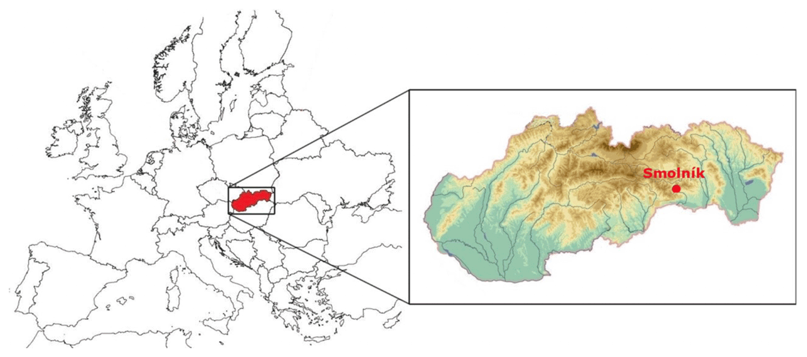
Figure 1Location of the mining town Smolník within Slovakia and Europe.
Given the current state of historical research, we are not able to relevantly answer the question about the exact point in time when the production of copper by cementation started in Smolník. Despite the fact that we have the first written record of copper ore mines from 1312, we cannot state that this was the beginning of cementation copper production, even though the principle of this process was known from ancient Rome (McNeil, 2002). This process is mentioned in the work of Roman naturalist Gaius Plinius Secundus (Pliny the Elder, 23–79 BCE; Jost, 2014).
According to the current state of historical knowledge, we are not able to accurately state when and where the knowledge of copper cementation emerged. However, two theses can be considered. The first is that the knowledge of cementation was brought to Europe from China at some point in time during the 13th century. This is the reasoning of Jost (2014), who writes that the knowledge of cementation came to Europe with the Mongolian troops at some point during the 13th century. Jost (2014) assumes that it was first known in the Middle East in the Arab world, where this process had been known since the beginning of the 13th century. From there, the knowledge was brought to Spain, where he assumes that the production of copper by cementation began in the 13th century, but he does so without relevant historical source materials to support his statement (Jost, 2014). If we were to follow this line of thinking, then we also have to bear in mind the historical fact that, between 1241 and 1242, the Mongolian troops spent several months in Hungary, only a few kilometres from the future town of Smolník, and that they had several campaigns in the territory of Spiš. The first written report on cementation in Smolník comes from this territory several decades later.
The second thesis states that the knowledge of copper cementation appeared in Europe independent of China, as evidenced by the report of Pliny the Elder from the 1st century BCE. This knowledge had been restored in the 16th century due to the interest of Renaissance alchemists in ancient science and the writings of ancient scientists. The process of iron-to-copper transmutation had served them very well in demonstrating the acquisition of gold from less noble metals. However, the process of cementation, which they could not explain, is mentioned in many writings in the 16th and 17th century, as this study further points out in the following.
The first written report on the production of cementation copper in Smolník is contained in a contract concluded in 1497 between Matej Turzo, the owner of iron works in Levoča, and Ján Donel, the chamber earl of the town of Smolník (Wenzel, 1880). This year is further confirmed by written reports (Neumann, 1904). The contract signed in Gelnica stated that Matej Turzo would supply iron at a price of 1 florin for 1.75 cnt of fine iron. Iron was to be delivered for copper cementation and for the production of pumping machines (kunst). From the contract, it is clear that cementation in Smolník was already under way. The exact beginning of this process is not known, and perhaps the report from 1346 could direct us better, stating that the cementation copper from Smolník was sold at the market in Košice (Juck, 1984). It is therefore very likely that the production of copper by cementation in Smolník began at some time during the first half of the 14th century, but it was probably already happening in the second half of the 13th century.
The first known detailed description of cementation in Smolník is retained in the report about a visit to the Spiš mining sites in 1520, which refers to the state of mines and the adjacent technical equipment for cementation in Smolník. Mining water was pumped by workers employed by the Sauer brothers, who rented the mines. Mining water had an important feature as it was used to obtain copper that precipitated on waste iron. At that time, there were many wooden troughs that could accommodate up to 3000–3500 cnt of iron (1 cent = 59.92 kg), which represented almost 210 t of iron. The Sauer brothers bought old iron in the whole territory of Spiš at a price of 40 denarii for 1 cnt of iron. The smelters produced approximately 400 cnt of copper annually from the precipitated and subsequently processed copper concentrate (dust). Their profit from selling the copper acquired by cementation was approximately 400–500 gold per year. Besides the cementation copper, they also produced copper sulfate. Their annual production of approximately 600 cnt sold very badly, while 1 cnt was sold only at a price of 2 golden coins (Vlachovič, 1964).
An interesting description is also provided in the work of an important alchemist, Paracelsus, which was derived from observations he made during his two visits to the mining towns in central and eastern Slovakia (former Upper Hungary) in the years 1521 and 1537 (Jesenský, 2005), when he also visited the town of Smolník personally. This description was published in his work De tinctura physicorum in 1570 (Paracelsus, 1570). According to him, we know that the cementation was handled by farmers or villagers when they deposited iron for an appropriate time period into a certain spring, commonly called the Spiš wells (Zippser brunnen). The iron was made (converted) to rust, which was melted in a fanned fire (in furnaces) and soon appeared as a pure copper. The copper obtained could never again return (be converted) to iron. Iron was allegedly instantly transformed into copper of the highest degree in a marcasite leachate (Ponduš, 1984). Paracelsus certainly thought of marcasite as a mixture of iron and copper pyrites.
A visit to the copper mines in Smolník (also in Švedlár and in Gelnica) was made in 1528 by Hans Dernschwam (1494–1567), the mining expert of the copper corporation of Banská Bystrica, who was employed in services of the Thurzo–Fugger company. He was accompanied by Matej Pribitzer and an unnamed Hungarian noble, who was sent by John Thurzo.
The report from this visit, which was probably conducted by Dernschwam, provides a concise picture of the state of mining production, including cementation in Smolník. This report shows that native copper was also obtained at that time by the so-called cementation, in addition to the mining of copper ores in the form of classic mining methods. Wooden troughs several metres long, which could contain up to 3500 cnt of cementation iron, were used for cementation. The Sauer brothers mined the iron in their own mines and melted it in their own smelters located in Smolník. They also bought old iron at a price of 40 denarii per 1 cnt of iron in the surrounding area. The annual production of up to 400 cnt of cementation copper was exported to Kraków and Transylvania.
Cementation was particularly interesting in terms of the development of ore treatment technological processes in Slovakia. According to Dernschwam's report, this was a process that could not be explained even by the renowned European scholars of that time and, hence, raised the astonishment of all contemporary scholars around the world, as well as in the ruling circles in Europe (Vozár, 1977).
Other historical sources mention the cementation in Smolník in the first half of the 16th century as well. A record from the year 1535 is kept in the town book of Smolník, mentioning that copper was also produced by cementation.
Another specialist who left us a report on cementation in Smolník from approximately same period as Paracelsus is Juraj (Georg) Wernher, the royal councillor of the Spiš chamber and the captain of the Šariš county. In his text, titled Hypomnemation de aquis in Scepusio admirandis, published before 1549 (probably in 1545 in Cologne, Germany), he writes the following:
So let me first talk about the water that has the ability to absorb iron. Such is near the town of Smolník, which is subordinated to the Spiš Castle. It is located in deep shafts, where ore was once mined. It is pumped by wheel pumps, and what flows out of them, flows into the underground channels and further into oak troughs, into which iron is inserted, either just recently smithed or older. Those pieces of iron, which are smaller, give up faster. A horseshoe can be decomposed in twenty-four hours. Those, however, which are thicker, and which are being prepared for this purpose in the adjacent iron ore mountains, are decomposed in a few days after being put into water, as if they were wrapped in some mud. For a few days they are washed and cleaned to keep the iron which was left, so that the strength of the water can penetrate more efficiently. What is left after the scattering of iron, something like a mud, as I said, is copper (usually called cement). And this is burned into solid in a furnace. It is then cleaned again in another melting furnace, and such purified copper is no less usable than what is obtained from the ore, which is being harvested in many shafts here. However, it is undeniable that water acquires these properties from ore veins, especially from pyrite (commonly called marcasite). (Rebro, 1996)
Wernher (1549) also published this report in a shortened form in a newer work called De admirandis Hungariae aquis hypomnemation (Report on the miraculous water of Hungary). Here he wrote about the process of obtaining copper from mining water in Smolník using embedded iron objects. The sedimented material contained copper that the miners called “cement”. The copper sediment that settled in this way was melted in a furnace and was afterwards refined in the second furnace. The copper obtained this way had the same properties as copper obtained from ore using the classic technology. Wernher (1557) attributed the transmutation capacity of cementation water to a substance which he called “marcasite”. This substance was in fact pyrite contained in cementation water. The alchemists sought to prove from this process that nature itself is able to acquire copper from iron, that is, to create one metal element from another one. This question awakened a fundamental dilemma amongst the scholars (Karpenko, 2005). Is the process of iron-to-copper transformation alchemic, or does iron only help in creating or concentrating copper?
Another major work about the history of copper cementation in Smolník (named Smolnici in Daciae but not in Hungariae) is an article written by Agricola (1546), who was an important mining expert of the 16th century, in his work De Natura Fossilium. Here he writes about the use of iron for the production of copper from mining water (“Ferrum quique alieno inficitur colore, Siquidem aceto & alumine uel injecto sutorio ilitum, fit aeri simile”). The water taken from special pits is poured into troughs arranged in series of three. Pieces of iron are inserted into the troughs and gradually covered with a yellowish coating; they change to copper. This copper is then refined in a furnace. The water (atramentum sutorium or ferrous sulfate sometimes mixed with copper sulfate) is created by flowing through mineral veins that are connected by natural channels (cracks). This process was carried out in the town of Smolník in the Carpathian Mountains in Hungary (“Smolnich, quod oppidum est Carpati montis eiusque partis Vngariae”).
Information about the cementation in Smolník was also given by Andrej Smoczký, an alchemist from Červený Kláštor in Upper Hungary. He wrote about the transmutation of iron into copper, which he understood only as a medieval alchemist (see his text Vade mecum at ego tecum from 1563, on page 168, in the chapter titled “Ferrum in aes commutare”). He also writes that there is a spring in the Carpathians, one of the mountains of Pannonia, in the town of Smolník, from which the water is pumped through three channels. Pieces of iron embedded in this water change to copper (Jesenský, 2009). If the iron objects were thinner, they reportedly changed to copper faster. This copper was then melted in fire (Herčko, 2002).
The monarch at the time had an interest in mines in Spiš county and in other mining areas of the present-day Hungarian Empire; therefore, mining experts were sent for visits at more or less regular intervals. Some interesting reports are preserved from the town of Smolník as well. After 1522, another commission, whose task was to investigate the state of mining and, hence, the cementation in the town of Smolník, was sent to Spiš in 1566. The commission noted that, before the water came to the surface, it ran through the higher horizons of mines, through old mining works called zroby. Water was obtained using 12 to 15 m deep shafts into which the water flowed (Ilavský, 1993). The cementation water was then captured in water collection tanks (ponds or sumps) into which chalcopyrite (called kýz) was added to make the water more concentrated. The enriched cementation water was then pumped out, using the kunst (a pumping machine), to the surface. It was brought into the troughs, where the copper was precipitated on the submerged iron. The copper sediments (šlichy) were then swept (scraped) from the iron 2 or 3 times a week and were taken to the smelter after drying out. Approximately 500 cnt of quality copper was produced annually (Gruss, 1938). As a result of an increase in the cementation copper production, a new shaft was excavated to open the pyrite bearings. The cementation water flowed into the tanks on the surface, where the cementation took place (Jesenský, 2010). The technological process of cementation given in the report is described in detail more than 100 years later in Luigi Ferdinand Marsigli's map from 1697, and it is described in its legend (the map is stored in the Bibliothéque nationale de France, Paris). At that time, approximately 500 cnt of copper per year were obtained by cementation and were sold to Anton Rollo, the copper seller in Levoča (Bergfest, 1958).
The town of Smolník was not the only European site where copper was commercially produced by cementation during the 16th century. The process also took place in Špania Dolina (Herčko, Ambroš and Hvizdáková, 2014) in Upper Hungary (present-day Slovakia), the Rio Tinto in southwestern Spain (Lung, 1986), and the Harz Mountains in the central part of northern Germany (Habashi, 2005).
2.2 History of cementation in Smolník in the 17th and 18th centuries
An anonymous encyclopedic work titled Rerum hungaricarum scriptores varii historici, geographici (Anonymous, 1600) contained the chapter “Hvngariae Aqvis” (Hungarian water), which described the mining of cementation water and the production of copper by cementation in Smolník. It is a general tractate which summarises the known and published information on copper cementation in Smolník. The following general description of the process can be summarised from the Latin translation.
As soon as the German guests became attracted by the presence of metals in the mountains (in the 13th century), they were given the right to found a town called Smolniciam (Smolník) in the Spiš county. Deep mines were gradually opened in the mountains. The water from the surface streamed into the underground mines and flowed over quality ore grains, which were often connected into nodes or cores. The water flowing in a continual flow through the rock in separate sectors of the mine was usually directed from the bottom of the wall by canals or wooden pipes stuck to the wall. The water penetrating into the mining underground washed the rock (pyrite) and created copperas (vitriolum). The captured water flowing out of the pyrite was then collected in an underground storage tank (pond or pool). The collected water was pumped out using a rag-and-chain pump (Heinzenkunst) or pulled up in leather bags. The green water containing large amounts of copperas (vitriolum) was brought into dug ditches (calledrygol) or into pyramidally assembled vats via wooden pipelines. Both old and new iron was deposited in them. The water drained from the mines flowed continuously through the iron in the tanks. As a rule, smaller pieces of iron were covered with copper faster. For example, a horseshoe was covered in 24 h. If the iron pieces were thick, they could be covered by copper few days after immersion. The layer covering the iron resembled mud, but it was copper, also commonly called cement (“… ferro manet luto simile, cuprum est ipsi vulgo cementum vocant”). The layer had been scraped off of the iron. The copper powder (material) was transferred to the melting furnace after drying. The product was then further melted in a refining furnace to make the copper cleaner. The use of cementation copper was the same as the use of the mined one because the quality was identical to the copper obtained by the traditional mining process in the nearby mines.
There was no doubt that the water pumped out of the metal veins had the same composition as the copper chalcopyrite (commonly called Marcasite) through which it flowed. It was also known that this water was accumulated from rainwater or from some other moisture or underground water. It was called vitriol (vocant vitriolum) in Smolník, Greeks called it chalcanthum, and in Latin it was called atramentum sutorium. An interesting conclusion can be found at the end of the description that the production of cementation copper (vitriolum) was only done there, i.e. in Smolník.
An inventory of the copper mines is preserved from 1631. According to the preserved inventory, we know that there were seven bigger cementation facilities in operation which were supplied with water from galleries and shafts. A total of four tanks filled with cementation iron were at the Požehnanie gallery, and there were up to 84 tanks filled with cementation iron at other mining works (Vozár, 1977). There were six cementation facilities in operation at the galleries of Seg, Sud, and Kalb and the shafts of Schew, Hosien, and Rotenberg, according to the records from 1634. The copper layer deposited on the iron surface was scraped from iron after 3–7 d and was transported into the copper smelter for processing (Vlachovič, 1957).
Written evidence of cementation in Smolník in the first half of the 17th century is given by David Fröhlich (1595–1648), a native from Kežmarok and an alchemist, geographer, and astronomer, in his manuscript, Medulla geographiae praticae peregrinantium printis usui (Fröhlich, 1639). The work mentions that copper was obtained by iron transmutation in Smolník.
An interesting description of cementation in Smolník is also provided in an autobiographical travel prose of Daniel Speer, a Silesian musician, who travelled in the territory of Upper Hungary (the present-day Slovakia) for 6 years sometime between the years 1650–1660, when he also visited Smolník. The original work, titled Ungarischer Simplicissimus (Hungarian Simplicissimus) was published in 1683 and includes a report which states that the mine owners in Smolník employed people who bought old iron in the surrounding territory. This iron was placed into wooden cases through which the miraculous water flowed. After 4 weeks, they drained the water, scraped off the sludge from the iron, dried it, and transported it to the smelter. Speer also claimed that he saw large amounts of coloured copper icicles growing not only out of rocks but also between the mining reinforcements. He also wrote that the water flowing from the cementation tanks into the Smolnícky stream was so polluted that all animals, including fish, otters, frogs, and others, died in the stream (Vlachovič, 1975).
According to the inventory of mines in Smolník in 1654, the upper shaft of Klab was 160 m deep. Above it was a whimsey with two driving ropes and seven leather bags, which brought the cementation water to the surface. Pumping machines, the bases of which were created by wooden wheels with 50 water containers, are also mentioned as being at two other shafts (Ilavský, 1993).
The Saxon Duke Ernest turned to Earl István Thököly with a request to investigate the cementation water in Smolník and to clarify the secret of iron to copper conversion in 1664. In his answer, Tököly described in detail the method of obtaining copper from cementation water using iron. His answer, with the description of how the iron in Smolník changed to copper, was exhibited in the Saxon Museum of Curiosity, where it was copied and published with further information by Georg Wolfgang Wedelius in the journal Ephemeri desnaturae curiosum in 1675–1676 under the title Descriptio, qualiter ferrum mutetur in cuprum in Smolnick (Herčko, 2002b).
In the years 1669–1670, or perhaps in 1672, the town of Smolník was visited by Edward Browne, an English physician, who was examining the cementation water as a proxy of the British Royal Society (Herčko, 2002a).
Private mines in Smolník gradually became a property of the public treasury (state) in the second half of the 17th century. The exchequer appears as the owner of the mines and the cementation facilities in Smolník, which he obtained by confiscating part of the property of István Csáky, for the first time in 1671. The exchequer became the majority owner of the mines and cementation facilities in 1690 when other shares from István Csáky were obtained (Magula, 2010).
The first written report that the cementation troughs were sheltered comes from 1680, during the rental of mines to Silvester Joanelli, because a new cementation building was built in that year. There were troughs, of which 54 were filled with iron and 38 were empty. An old shaft was reopened to supply the cementation water for the new cementation building (Vozár, 1977).
2.3 The first source materials for the research of cementation in Smolník
The most important archival document of cementation in Smolník at the end of the 17th century is the report by Luigi Ferdinand Marsigli (1658–1730), who came from the papal town of Bologna (Stoye, 1994) and was probably the most prominent naturalist who ever visited Smolník. A large work from his journey to Hungary in 1696 was published, including the first relatively detailed map of the cementation in Smolník mines (Fig. 2). An important scientist from the turn of the 17th and 18th centuries and a member of the French Academy of Sciences, the Royal Society of Paris, London, and Montpelier (Duka, 1974), summarised his detailed knowledge of copper cementation in Smolník in his extensive six-volume work titled Danubius Pannonico-Mysicus, observationibus geographicis, astronomicis, hydrographicis, historicis, physicis, perlustratus et in sex Tomos digestus (Danube in Pannonia and Moesia, examined by geographical, astronomical, hydrographical, historical and physical observations and discussed in six volumes), which was published in Amsterdam in 1726 (Marsigli, 1726). The second volume, which deals with this issue, is the most important not only for the study of cementation in Smolník but also for the general knowledge of the entire Slovak mining and mineral deposits. A particularly detailed description of the cementation in Smolník is given. Marsigli explained the formation of cementation water by spring water that dissolved particles of vitriol in the rock and formed the cementation water. The water then deposited copper by chemical action of iron. Marsigli also states that the copper particles were easily bonded with vitriol because vitriol is the main component of copper (Herčko, 2002b).
The aforementioned map, titled Fodinae Schmelnitzences (Mines of Smolník), is included in the second volume, titled About minerals, stones, and metals, as annex no. XII (Konečný, 2014). The map has a complicated orientation towards the cardinal points because it is oriented opposite to the common orientation of current maps, i.e. south is at the upper edge of the map. It also does not have a given scale, and it is distorted both horizontally and vertically, which complicates its georeferencing and the identification of individual objects. Marsigli himself points to this fact, stating that the Smolník cross section would require more precise measures, but he still argues that the separate parts of the mining underground, the technical facilities, and the ore veins are plotted in accordance with the real state (Herčko, 2002a).
The map (Marsigli, 1696) depicts a cross section of the copper mines in Smolník and gives a detailed picture of the process of cementation water mining in the underground of Spitzen Berg (Ostrý vrch; 818 m a.s.l. – above sea level), which is depicted in the centre of the map. On the right side on the map is a cross section of Rotenberg (Červený vrch; 838 m a.s.l.), which actually lies to the west of Spitzen Berg due to the orientation of the map. In the left part of the map, there is a cross section of the mountain ridge (810 m a.s.l.) lying east of Spitzen Berg. The legend describing individual parts of the map is in its top right section. An illustrious axis of the entire underground image is the representation of the main copper ore vein of Smolník. A detailed process of underground collection of cementation water is depicted with a number of water sources that are pumped using manual pumps further to the bottom of the central pumping shaft where the pumping machines are located to draw the water to the surface.
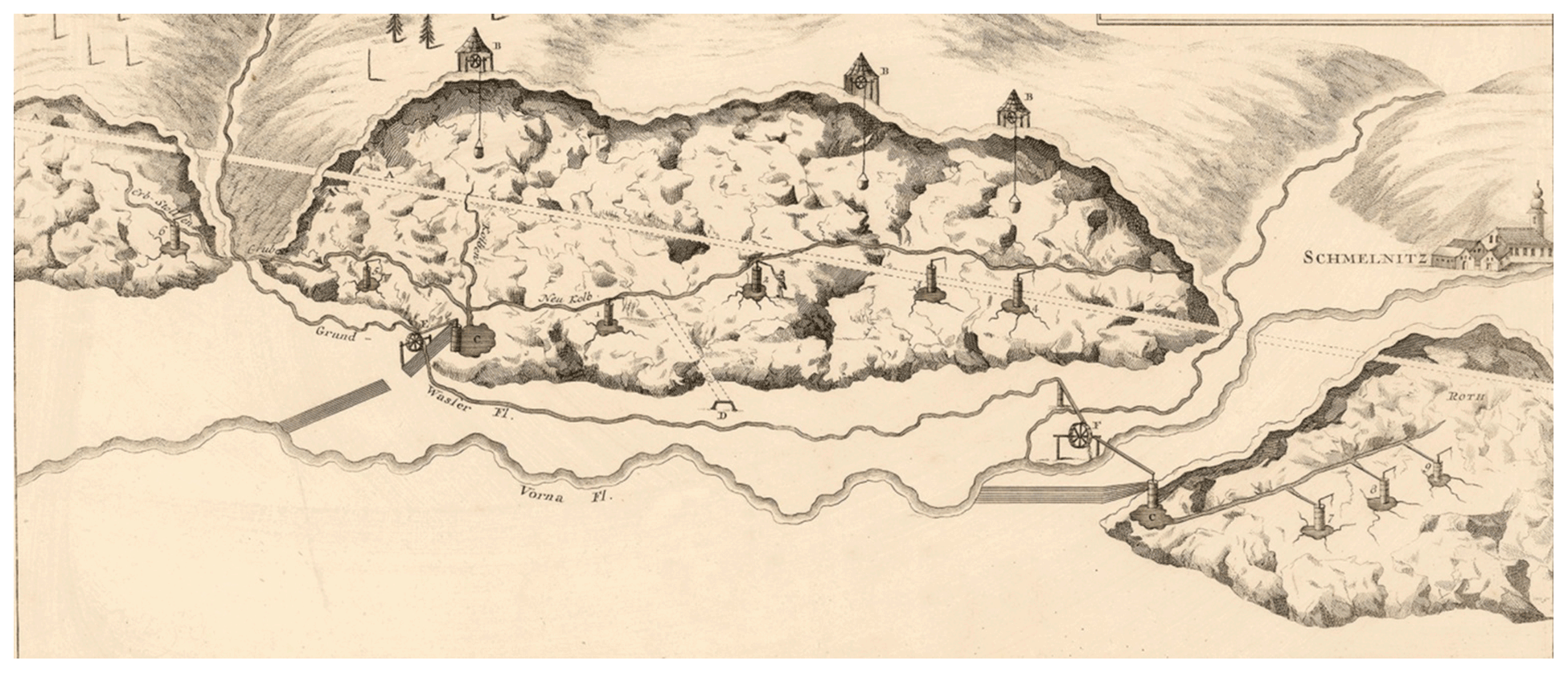
Figure 2The oldest view of the mines in Smolník on the map of Luigi Ferdinand Marsigli from 1696, published in print under the title Fodinae Schmelnitzences (Mines of Smolník). The map shows a cross section of the Smolník deposits, with a detailed view of mining of cementation water in the underground (source: the State Central Mining Archives in Banská Štiavnica, Slovakia; photo was taken in 2015).
The largest sources of cementation water were in the underground of Spitzen Berg, and the author refers to this mining field as being southern (del Monte meridionali). There were five manual pumps in the underground which, remarkably, resemble the manual pumps depicted in the engravings of Agricola in the middle of the 16th century (Petr and Petrová, 2006). These pumps transported water into a collecting gutter, which Marsigli called Neu Kolben. Cementation water then flowed down the underground to the east, where it was gathered in a pond at the bottom of an unnamed shaft in which the water-powered pumping machine (“Machina, quae attollit aquam vitriolatam”) was located. The pumping machines placed on the surface above the shaft were driven by and overhead propelled water-driven wheel to which the water was led by a flume (Grund Wasser Fl.). If Marsigli speaks the truth in that report, despite the inaccuracies of the map, then it shows the actual technical state of cementation, and we can assume that the lines leading from the shaft to the Smolnícky stream (Vorna Fl.) symbolically depict a system of six long cementation troughs lying next to each other. A relatively serious problem occurs with the identification of Marsigli's main pumping shaft on the northeastern slope of Spitzen Berg. According to the archival research carried out in the State Central Mining Archives in Banská Štiavnica (Slovakia), it could be the shaft called Fund Schacht, eventually named the Königer Kiesz Schacht (the royal pyrite shaft), whose role was later taken over by the shaft known as the Ioszephi Schacht, Józsefakna (Jozef shaft). There are three wooden circular shaft towers on the ridge of Spitzen Berg depicted on the map, with which the ore was pulled up in bags by a winch and was sorted in the shaft buildings. However, these shafts cannot be identified due to the inaccuracies of the Marsigli map and due to a large number of shafts (up to 67) that were located here during the first half of the 18th century. A shaft depicted in the centre of the northern foothill of Spitzen Berg can be identified with the historical shaft, Kalb, which was already documented in 1634 (Vlachovič, 1957).
The cross section of the so-called northern mining field called Roth (de Monte Septentrionali, Roth dicto) is depicted west of the Spitzen Berg mining field. The underground situation is analogous to that of the previous mining field, with the fact that only three manual pumps are depicted in the underground probably indicating smaller sources of cementation water. Pumping to the surface by an unnamed shaft was technically the same as well. Assuming that Marsigli's evaluation of his own map was right, we can again state that there were seven cementation troughs between the shaft and the Smolnícky stream, but these were shorter, as in case of the southern mining field. The unnamed shaft in the Roth mining field, located at the southeastern foot of Rotenberg according to Marsigli, can be identified as the Roth Schacht shaft, which was the only main pumping shaft in this period, according to the map drawn by Christoph Traugott Delius on 15 September 1755 (deposited in the State Central Mining Archives in Banská Štiavnica, Slovakia; the map is from 1755, and the photo was taken in 2015). The three major pumping shafts, i.e. Unter Rothenberger Kunst Schacht, Obere Rothenberger Kunst Schacht, and Königl Neu Kunst and Wasser Gappel Schacht, are documented later in the first half of the 18th century. A part of the veduta of the town of Smolník (Schmelnitz) is depicted south of Rotenberg on the map.
The only named shaft in the Marsigli's map is the shaft of Erb Stollen, which carried the cementation water from the underground of the ridge (810 m a.s.l.) between the Ostrý and Štósky hills (865 m a.s.l.), which is the eastern part of the southern mining field. This shaft was named Wasser Stollen in the 18th century. The cementation water was pumped into this shaft by one manual pump and then channelled to the cementation tanks of the southern mining field.
Cementation in Smolník in the first half of the 18th century is known from the work of the medical doctor Frantz Ernst Brückman, a member of the Imperial Academy of Natural Specialties and a member of the Royal Prussian Society, who visited this mining town in 1724 (Herčko, 1975). His reports were published in the work titled Magnalia dei in locis subterraneis, which was printed in Braunschweig in 1727 (Brückman, 1727). On page 262 in chapter XVII, “Bergwercten in Unger und der Turckey”, he firstly mentions the town of Smolník in the forms of Schmölnitz, Smölnitz, Selmonicum, Szmolnokium, and Szmolnok, describing it as a mining town which lies on the river Gelnica (Goelnitz) in the Zips Comitat at a distance of 24 km from Rožňava (Rosenau). The text actually states that the town has nice copper mines and cementation water (“hat schöne kupfter-Bergwercte und Caement-Wasser”). Regarding the cementation itself, the document states that the cementation water (Caement-Wasser), which local men called Ziment-Wasser, is pumped to the surface using pumps called kunst. The cementation water flowed through more than 300 cementation troughs with iron situated in the underground but especially on the surface. The water covered the iron, and high-quality copper was formed by the process called precipitation. Cementation produced 7000 cnt of pure copper annually, while it converted up to 600 cnt of iron to copper (Brückman, 1727).
The state, as the new owner, was expecting continually higher profits from the copper production. For this reason, it needed to keep an eye on the activities and yield of the mines and cementation facilities. Therefore, the state sent a commission, which wrote a detailed report (deposited in the State Archive in Levoča, Slovakia; the document is from 1725, and the copy was obtained in 2017) titled Protocollum Proiecti quid nam Investigationibus et Liqquefacturarum Szomolnoki omitendum, quid item ordinandum fores on 28 January 1725. Apart from the already known facts about the cementation technology, the commission focused on improving the technical equipment and the technological processes of cementation. For example, it recommended capturing dirt in the mining water by constructing wooden cases for sedimentation at suitable locations. The feeder canals on the surface had to be covered with hatches to prevent dirt from falling in or being blown in by wind. Iron of the same grade and quality had to be used. The commission also recommended that short iron rods should only be laid transversely to the direction of the mining water flow. The most important recommendation of the report was that it was necessary to increase the volume of the cementation water in order to increase the production of copper and, thus, the profit for the state. Therefore, members of the commission recommended artificially supplying the surface water to the deposit areas in the mining corridors where the copper sulfate was deposited in the largest amount. The water was then to be drained away, stored, and used as the other mining water. Surface water was also supposed to be fed into surface heaps through which it should circulate freely and wash through the heap material.
The plan to increase the volume of cementation water already began to be realised in the 18th century, according to the direct historical evidence from Christophe Traugott Delius, a significant Montanist and professor at the mining academy in Banská Štiavnica, who stated that the Smolník cementation water was obtained mainly by the surface water being fed into the old mining works and heaps in 1773. The process of obtaining cementation water required the construction of an extensive and complex water management system that supplied water not only into the excavated spaces and old heaps where it was converted into cementation water but also increased the amount of available water, which was also necessary to drive the pumping facilities, such whimseys, and to process the copper in the smelters (Delius, 1806). The entire water management system was completed during the 18th century and became the second largest in Upper Hungary after the water management system of Banská Štiavnica (one of the largest in the world). Since its construction was as a result of the expansion of cementation, we will give a brief description of the process.
The mining exchequer stepped up the more efficient use of water resources and built a water reservoir under the village of Úhorná, in 1768, in which mountain springs and precipitation water were stored (Magula, 1977). The catchment area of Smolnícke valley was insufficient to cover the needs of the mining operations, so a parallel connection of the Bystrý stream to the water management system of Smolník was created by driving the Theresa water shaft from both ends. The construction ended in 1796, and the shaft was named after Empress Maria Theresa. From that time, the water from the Bystrý stream, Zdjar, and Hüttengrund, up to the estuary of the Bystrý stream of the hereditary gallery, was fed through a canal measuring 256 fathoms (1 fathom = 1.8 m) into the 1836 m long Theresa gallery, and from there it was fed into Smolnícke valley. This water was used for mining operations until the 20th century.
Another water canal with a total length of 891.5 fathoms was built parallel to the main valley and diverted water from the Smolnícky stream to the pumping machine at the shaft Rotenberg, from where it continued further and fed the water to the shaft of Grosskunst.
The water canal that supplied water from Breitengrund (Široká dolina) and Rothwasser (Červená Voda) up to the mine-waste tip of the shaft named Elizabeth had a length of 1100 fathoms. The length of the parallel water canal, supplying water from the Schläglersgrund up to the mullock tip of the shaft Nová and from there to the highest located inlet troughs, was 290 fathoms. The total length of the artificial water canals constructed was quite significant. It reached a length of 7374.5 fathoms, of which 1306 fathoms were in form of water galleries (Magula and Brehuv, 2004).
Ernest Georg Multz de Walda was one of the members of the commission, which examined the mines in the district of Smolník in 1747, accompanied by the mining counsellor Sigismund Kompoty and the smelting counsellor Franz Josef Ruprecht. According to this commission, the mines in Smolník were in operation at Rotenberg, Spitzen Berg, in the valleys of Breitengrund and Rothwaser, Höllenhoh, Grassigerweg, and Bärengrund. The copper ore also contained some silver, except that the silver, copper, gold, and antimony were also present in all mines. Old abandoned mines were located at Beckengrund, Teichgrund, Schmellenseifen, Kirschgründ, Bukovina, Kobuláre, Baniská, and Weissenbach. The mining works were carried out at a depth of 275 m below the surface at that time. New pumping equipment, the so-called kunst, was used to pump water. These were also used to drain the old mining works suitable for mining (Ilavský, 1993).
The year 1748, from which the oldest depiction of the cementation process in Smolník is known, can be considered as a breakthrough year in the research of the history of cementation in Smolník. It is found on the parergon of the General Map of Mining Works on the hill of Spitzen Berg in Smolník (Fig. 3) drawn by Jan Gašpar Reitzner and Franz Anton von Steinberg. It shows an extensive artistic but also a highly professional and valuable parergon at the bottom of the map, which depicts the work processes from ore mining in mines to ore processing in the smelters, including the cementation. We can assume that the pen drawing is historically relevant because the other mining–metallurgical workflows displayed are also correctly drawn. The quality of its content is also highlighted by the education and working positions of authors, who worked as mining surveyors and cartographers, with Reitzner becoming a senior mining manager a few years later. The depiction of cementation (like the whole of the parergon) is painted with a gentle, sky blue coloured stream of mining cementation water. It is possible to observe the whole process of cementation on the surface in detail.
The process can be deduced as follows. The pumping machine (kunst) was powered by a top-driven water wheel. Propulsion water was fed through a simple wooden bridge (trough) to have sufficient driving power when falling on the wheel blades. The pumping machine itself was located in a wooden shingle-covered log structure. The tie rod mechanism led to pumps, which pumped the cementation water under a relatively long, shingle-covered shelter. A wooden shelter with a shingle roof was built above the mouth of the shaft, so that all three buildings formed one compact unit. Spare parts of the pump and wooden pipes are depicted in its vicinity. The pit of the shaft is modified and reinforced by a wooden cribwork in which two pumping machines are located. The pumped water is gravitationally fed through a wooden supply chute into the uncovered sedimentary wooden troughs. There are quite a few short iron rods placed into the cementation troughs by one worker. The other worker controls the ongoing process or removes the iron already covered with copper by the water below in the sedimentation troughs. Women also worked at the cementation, mostly transporting the scraped copper powder in a large pan on a wooden rod across their shoulders. There is also a wooden covered chest depicted nearby, which probably served as temporary storage of the scraped precipitated copper before it was transported to the hut.
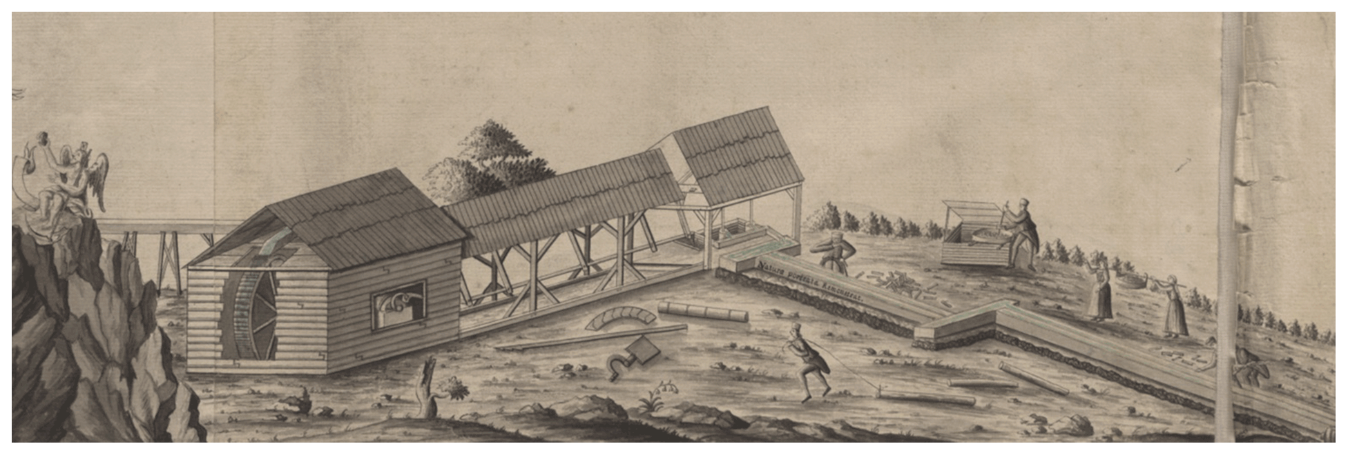
Figure 3The first known depiction of the cementation process in Smolník on parergon of the General Map of Mining Works (1748) on the hill of Spitzen Berg (source: the State Central Mining Archives in Banská Štiavnica, Slovakia; photo was taken in 2016a).
An interesting piece, which is a watercolour artwork, is the map of Captain Geyer depicting the mines of Smolník and the city in 1751 under the title Plaan der Legstadt Schmelniz (Fig. 4). In its upper left corner, the map also schematically shows a cross section of the mine in which the cementation water was extracted. In the background of the mine is a picture of a wall with an outflowing spring of the cementation water fed into the pond using a gutter. The water was drawn from the pond up to the surface using a water shaft (Wasser Schacht). The building with the winch, which pulled the bags, stood on the surface above the shaft. The cementation water also flowed to the surface gravitationally through a water gallery (Wasser Stollen). Individual parts of the mine are also named in the legend. A total of two copper blast furnaces are plotted in the lower left part of the map, and a schematic plan of the town of Smolník with the surrounding mines and water management facilities is depicted in the right half of the map.
The pumping equipment in Smolník was built at the Spitzen Berg and Rotenberg deposits, and the deep mining began in 1751. A pumping machine with a lever drive was built at the Rotenberg shaft, which had a depth of 86 m. The wooden bar mechanism was driven by a 15 hp (11 032.35 W) water wheel located approximately 90 m from the shaft. Its drive was provided by the flowing water supplied by the flume from the Smolnícky stream, with a falling gradient of 8.4 m and a flow rate of 0.12 m3 s−1 of water. The machine pumped cementation mining water for the cementation facility located near the shaft. The bar pumping mechanism remained as a unicum until the end of the 1890s (Magula, 1985).
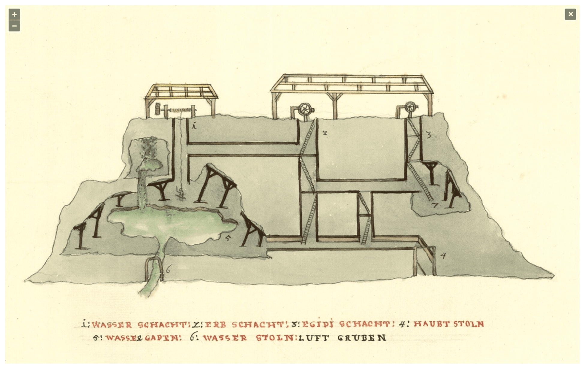
Figure 4A cut-out from the Geyer map (1751) schematically illustrating the mining of cementation water in the mining underground and its pumping to the surface (source: the Moravian Library in Brno, 2020, Czech Republic; the copy of the map was obtained in 2020).
The town of Smolník became a subject of an exceptional attention of an excellent scientist named Ignaz Anton von Born (1742–1791), founder of the Czech Private Learned Society, who visited Smolník in September 1770 during his short stay in Banská Štiavnica. He described the mineralogical and bearing conditions in particular. Among the three main Smolník veins, the middle and the hanging wall veins deserved attention for their mass yield. Large nests of pyrite were found among the major veins in the clay shale (Magula, 1981).
A historically important cartographic document on the history of cementation in Smolník is a hand-drawn map of the Smolník Chamber Estate (Territorial Plan über die zur kay[serlich] könig[lichen] Schmölnizer Kupfer Handlung gehörige privilegirte ober hungarische Berg Stätte Schmöllniz, Schwädler und Stooss; see Fig. 5), which was drawn in 1774 by Ján Lill and Ignác Gottier under the leadership of Gaspar Reitzner, the chief mine superintendent of Smolník.
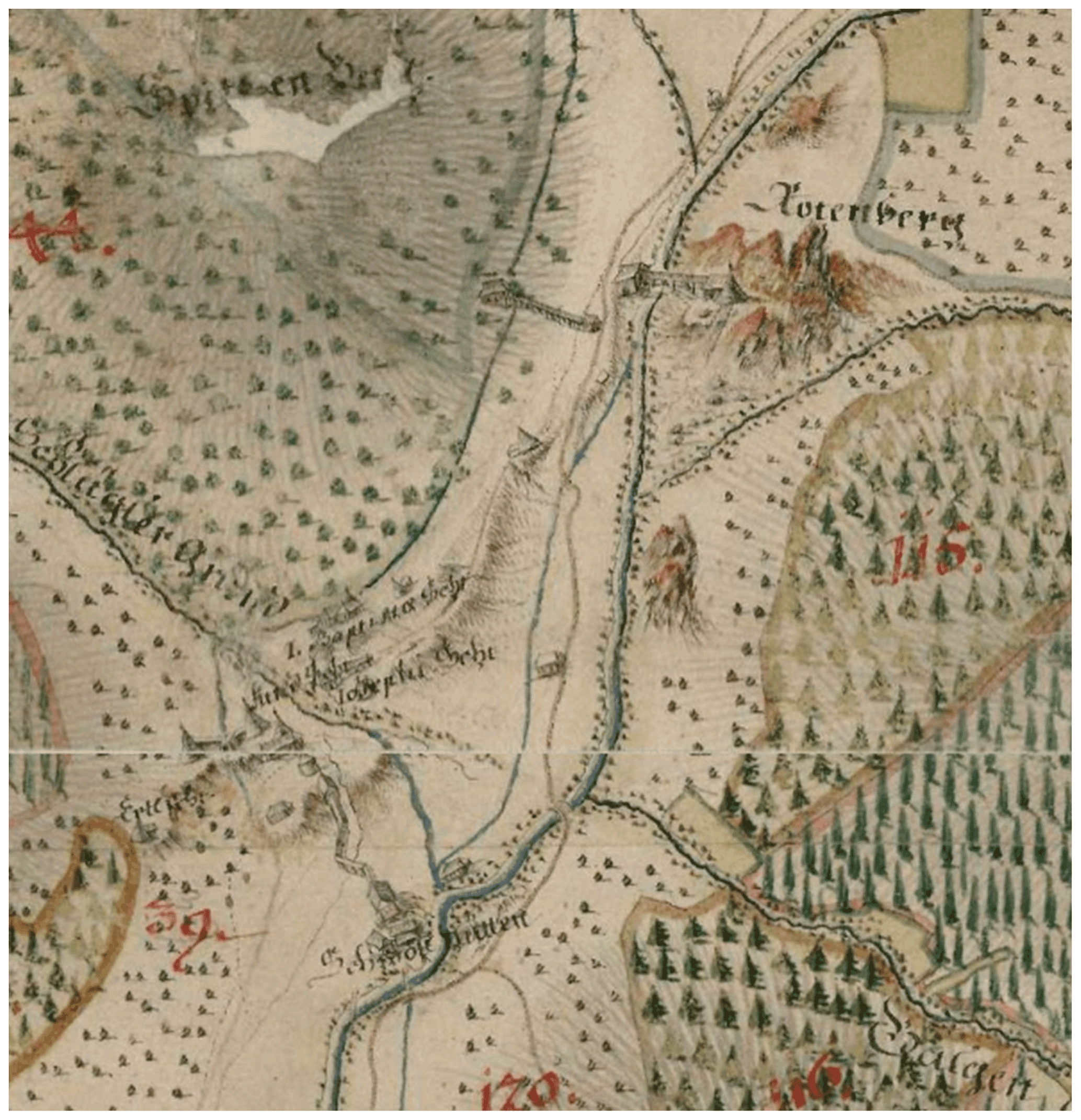
Figure 5Technical facilities and buildings of copper cementation facilities in the Rotenberg and Spitzen Berg mining fields depicted in the map of the Smolník Chamber Estate (1774) (source: Országos, Széchényi Könyvtár, Budapest, Hungary; the copy of the map was obtained in 2016).
The map depicts a number of cementation facilities, two of which are displayed in the same position as in the map of Marsigli. One cementation plant was located on the eastern–southeastern slope of Rotenberg. The whole wooden system of the cone structure, under which the pumping whimsey was located above the shaft, was depicted, including the roofed cementation tanks that led to the Smolnícky stream. The second roofed cementation facility, of approximately the same size as the one at Rotenberg, was located on the northwestern slope of Spitzen Berg. It began with a wooden building before the mouth of the Kalb gallery from which the roof-covered cementation tanks were built. The third and largest cementation system was located on the northern slope of Spitzen Berg. It was supplied with the cementation water from a cone-covered shaft from which a long roofed cementation tank strip extended. The map also shows three smaller cementation facilities. The one on the slope west of the Spitzen Berg was supplied with water from two shafts. The facilities are also depicted at the Baptista and Jozephi shafts on the northern slope of Spitzen Berg. Based on the map, it is obvious that all of the machines on the slope of Spitzen Berg were driven by the water supplied by the Grom flume from the lake of Úhorná.
Students from the University of Pest (now called Eötvös Loránd University), Dominik Teleki von Szék and his friend, Horváth, stopped in Smolník on their scientific journey in June 1793 (Herčko, 2000). In addition to the mines, both travellers were also attracted by the remarkable machines used for water pumping and for transporting of ore to the surface. The machines were operated by large water wheels with a diameter of 6–7 fathoms. The water flowing from the Smolník mountain range contained cementation copper, and the copper ore was mined in form of chalcopyrite.
In his travel document titled Reisen durch Ungarn und einige angrenzende Länder, Teleki (1805) also states that there were several shafts in the vicinity of Smolník which were increasingly deeper and more profitable. A few smelters were evidently present as well. The ore was first sorted, according to the copper content, into richer and poorer quality ore. Next, the ore was crushed and transported into smelters. The ore was then whitened out in the flames of the melting furnace, and the whole process was repeated 3 times until the crude melt was obtained. The obtained yield was then taken to the second hot furnace, where the black copper (copper sulfides) was made by roasting. Then it was put into a special furnace for the last refining where it was melted in small rounded melting pots, from which the copper was extracted in form of plates.
Teleki (1805) also pointed out in his travelogue that the copper ore also contained gold or silver. Therefore, it had to undergo chemical tests so that the noble metals could be extracted. If the copper contained sulfur, it was put into special furnaces in which charcoal was deposited.
Teleki (1805) was surprised that Smolník had no special buildings, except for the mint, in which copper coins were minted. The inhabitants of Smolník were Germans and Slovaks. Most of the mines belonged, at that time, to the mining exchequer and is among the oldest in the territory of Upper Hungary. Smolník formed a separate mining district as a mining town, with its own mining administration, together with the existing settlements. Štós, Švedlár, Mníšek and Hnilcom, Gelnica, Krompachy, Nálepkovo, Vyšný and Nižný Medzev, Dobšiná, Rožňava, Spišská Nová Ves, and Spišská Vlachy all belonged to the supreme inspectorate at that time.
2.4 The end of the golden period of cementation in Smolník in the first half of the 19th century
A report from 1825 states that the old mining works on the Katarína and Karol shafts were purposely flooded with water in order to obtain high-quality cementation water. The production of copper in Smolník in 1835 represented a total of 769 cnt and 73 funts of copper, of which up to 534.34 cnt were of cementation copper (Bergfest, 1958). Extensive investment works began in 1834 and lasted until 1842. The progress in technique, and demands for a large quantum of copper, quite logically required such redevelopment. Modernisation efforts included amendments to the main mining facilities, the cementation, and the smelter. The ratio of cementation copper to the total copper production fell to the level of the early 19th century.
Peter von Rittinger, the district councilor at the Ministry of Agriculture and Mining in Vienna, proposed building a two-cylinder horizontal water column pumping machine in the Jozef shaft (248 m) and a water column pulling machine in the Fund shaft to expand the cementation facility. The proposal also highlighted that the cementation water does not allow the use of cast iron pumps, and that wooden pumps should be used in the Jozef shaft. The interior of the piston pipes, made of the finest wood, had to be smooth to not be damaged by the moving pistons (Kladivik, 1991).
Metalwork in Krompachy constructed a water column machine for the Jozef shaft based on the approved design according to the plans of Johan Adriany on the set date. The machine was put into operation on 28 November 1854, after being set up in the Peter shaft. It was the most powerful water column machine in the mines of the Habsburg monarchy at that time, with a theoretical power of 98.6 hp (72.5 kW). Its propulsion was secured by water supplied from the flume of the water reservoir of Úhorná.
Pumping of cementation water on deposits, which had previously been provided by kunsts in the Jozef, Theresa, Wind, and Grosskunst shafts (while only the last one mentioned was left in operation), was made significantly more effective after the setting up of this pumping machine. The pumping mechanism consisted of 132 pump sets that formed 33 pump groups together. The pipes themselves were relatively short. They were always fastened to the beams (rods) in groups of four. The output of the pumping mechanism was 227 L min−1.
As mentioned previously, the peak of the cementation production in the town of Smolník took place in the middle of the 19th century. The state of mining spaces, cementation water, the formation of higher amounts of cementation water using surface water supply, the technical equipment, the cementation process, the metallurgical production of cementation water, and the environment are highlighted in an extensive study by Antal Hauch (1860) in the scientific journal Österreichische Zeitschrift für Berg- und Hüttenwesen (Austrian magazine for mining and metallurgy).
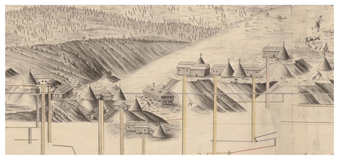
Figure 6Mining technologies in Smolník in the 18th century (source: Slovak Mining Archive, Banská Štiavnica; the copy of the map was obtained in 2016a).
From the descriptions and conclusions of Hauch (1860) in relation to cementation, it is necessary to mention that the dissolution of sulfates was done on four newly created horizons with a height difference of 4, 7, 9, and 11 fathoms. The process was carried out in new, specially excavated corridors, which were excavated consecutively and transversely to the entire bearing thickness at a distance of about 10 fathoms. The surface water was supplied into these corridors through the shaft by wooden pipes and from there by wooden chutes. Cementation water was captured at the end of the process in a drain well on the main horizon, from where it was pumped to the cementation facility using shafts, as it was a common practice in the past. The leaching process was carried out systematically, and the content of the copper leached in water was regularly monitored. One leaching phase usually took 3 months and depended on the copper content in the mining water.

Figure 7Mine map from the early 19th century showing the underground for cementation water mining in the mining field of Spitzen Berg hill (source: Slovak Mining Archive, Banská Štiavnica; the copy of the map was obtained in 2016b).
Pyrite ore was also mined in the underground and exported to the surface onto special heaps where the leaching was done, mainly because of lack of space underground. The old heaps on the surface were considered to be without the possibility of economic use for cementation during this period. Water from the surrounding springs and streams was then fed through a 1600 fathom long (approx. 2.2 km) wooden pipeline into newly established heaps to carry out the leaching process. The water ran off into the dry walled ducts that brought it to the cementing plants after it flew through the heaps.
According to Hauch's (1960) notes, the cementation tanks in Smolník were 3.79 m long, 31.61 cm wide, and 26.34 cm deep (after conversion to the metric system). The individual sedimentation troughs were interconnected on an inclined plane, and their inclination was 4.15 cm per metre. The total length of 936 cementation troughs in Smolník was 3550.17 m in 1860. Iron bars 26.34 cm long, 6.59 cm wide, and 1.32 cm thick were loaded into the sedimentation troughs. They were stacked across the entire width of the troughs and were placed alternately in grates to allow the free flow of water. The weight of all of the iron used was up to 1120.12 t, while the average weight of one bar was 2.07 kg. The total sedimentation area was up to 13 112.79 m2, using the grate iron-depositing method. In order to ensure the precipitation of all of the cementation copper from the water, the water continued to flow into 30 vertical sedimentary closed prisms, which had smaller dimensions to the troughs. The copper precipitated on iron from the troughs was scrubbed after draining and drying every 2 weeks, and as needed in the residual chambers, but most often every 4 weeks. The scraped dust was then transported to the smelter for further processing. The process of cementation produced, on average, from 140 to 188 t of copper annually at the beginning of the second half of the 19th century.
Figure 8Visualisation of mining underground in Smolník in historical map (source: Slovak Mining Archive, Banská Štiavnica; the copy of the map was obtained in 2016a).
A detailed state of the mining underground – water galleries in the largest mining field of Spitzen Berg in the middle of the 19th century – is known thanks to a mining map preserved in the State Central Mining Archives in Banská Štiavnica; the copy of the map was obtained in 2016 (registration no. 9470). According to the map, the artificially formed cementation water was produced in two horizons. The side galleries brought the cementation water to the main collecting gallery, which led, gravitationally, to the collecting tanks at the pumping shafts. The cementation water was pumped from the deposit with four shafts called, according to the Hungarian nomenclature, Ersébet akna, Fund akna, Jószef akna, and Baptista akna.
The exact profile and ground plan of the cementation water underground mining spaces at the Spitzen Berg deposit near the Jozef shaft (Jószefakna) is depicted in the mining map painted by the royal mining gauger Dionýz Szücs in the middle of the 19th century. The map, deposited in the State Central Mining Archives in Banská Štiavnica (Slovakia); the copy of the map was obtained in 2016, very accurately depicts also the ground plan of the surface objects, including the large cementation building at the Jozef shaft. The main cementation building, in which the cementation tanks were located, was 110 m long, 10 m wide at the upper part, and 21 m wide at the lower part. The building in the map is named Rézejtés, using the Hungarian nomenclature, which means copper sedimentation. The map is the only known document that shows the feeder gutter of surface water leading into the underground of the mine on the northwestern slope of Spitzen Berg (opposite to the mouth of the Mlynovec stream), which was used to increase the volume of the cementation water. The gutter led to the water inlet (drainage) gallery (vízvezetö tárna). As the gutter is referred to as the top (felsö vízvezetö árok), a similar gutter and a gallery had to also exist somewhere on the eastern slope of Spitzen Berg.
An interesting record about the cementation in Smolník is preserved from the beginning of the second half of the 19th century, thanks to Gusztáv Faller (1816–1881), an excellent mining engineer and professor at the Mining Academy in Banská Štiavnica, who was born in the nearby town of Gelnica. He was not only an expert in mining and mining technology, but he also had an expert knowledge of the local region. His knowledge of cementation in Smolník is summarised in the work titled Beschreibung einiger wichtigerer Metallbergbaue der Komitate Zips, Gömör und Abauj in Oberungarn, published in Banská Štiavnica in 1868. A description of the state of cementation in 1866 is given on pages 74–79 (Magula, 1977). According to the description, the cementation facilities in operation were using water from the following sources: Rotenberg – water was pumped from the shaft of the same name; Karitas – water was flowing out of the gallery; Windschacht – water was pumped from the Jozef shaft; Baptista – surface water that flowed through the heaps of the Elizabeth and Fund shafts was used, as well as water artificially fed into the heaps; Grosskunst – water was pumped from this shaft and partially from the Jozef shaft; Wiedersteuer – partially de-coppered water from the cementation at Grosskunst and Baptist was used; Letzterhoben (last stage) – already partially de-coppered water was used, which was brought into this cementation by a water wheel pump; Kies gallery – used surface water leaked through the heaps of the Fund shaft with a canal feed; and Kalb gallery – water was flowing out of the gallery.
A gradual decline in cementation can be seen following this period. For example, only four cementation facilities were in operation in 1896, namely Jozef, Grosskunst, Baptista, and Rotenberg. Approximately only 36–40 t of copper per year were produced during this period (Schifter, 1938). The cementation gradually declined further until it was completely stopped in 1963. Several attempts to resume production after this year were not successful (Schenk, 1966).
At the time of the above cementation process in Smolník, we can also observe the origins of scientific mining tourism in the territory of present-day Slovakia. The historical works, writing, or travelogues of scholars who visited the site in question during the period under study are an important source of information. These journeys can be considered to be the first scientific journeys in connection with mining tourism development in the Western Carpathians.
Thanks to the geological conditions in the mountain range of the Western Carpathians, present-day Slovakia has been almost the ideal geographical area for the origin and development of mining since the beginning of human settlement. This is one of the reasons why Slovak mining has been associated with many firsts since the very beginning of its development. The proof of this is the former free royal town of Smolník (Figs. 6, 7, and 8) which, as the first in former Upper Hungary, started to use the process of copper production by cementation. Mainly due to this fact, Smolník began to be discovered and visited by many important scholars, naturalists, and polymaths of the time from as early as the 16th century. One of them was Paracelsus, who can be considered a pioneer of mining tourism in modern Slovakia.
His journey can be described as a scientific mining journey because, as an alchemist, he was interested not only in ore mining but also in mineral and cementation water during his travels.
Smolník was also visited by Daniel Speer, Edward Brown, Luigi Ferdinand Marsigli, Franz Ernst Brückmann, Ignaz Anton von Born, etc. Their scientific interests and the information they gained during their travels were published in several scientific papers and travelogues in many languages. It is thanks to these written records that we can learn more about the mining at that time, the used technologies, and the cementation in Smolník.
Since in most cases these visits to Upper Hungary and the town of Smolník were associated with interest in mining and the study of the cementation process, we can consider these type of travels as being the beginning of mining tourism, which is currently considered part of geotourism or industrial tourism. Given that these were scientific journeys, we could, however, also then assign them to the scientific tourism.
At present, when mining tourism is associated with both mining experts and scholars and the general public, it often not only fulfils its educational function but has a much broader dimension and is connected with recreational, sports, cultural, experiential, or adrenaline activities that come with modern forms of tourism. In the past, the contemporary (pioneering) mining tourism was associated exclusively with scientific, purpose-driven, and practical goals and not with relaxation, rest, or experiences. This is one of the reasons why it can no longer be exclusively classified as part of scientific tourism.
The nature of scientific (and mining) journeys began to change at the end of the 18th century. Although travelling still had a predominantly educational purpose, it gradually began to take in a romantic approach (perception and admiration of the beauty of nature and landscape). The view of travel and tourism of the 18th century has changed significantly, especially under the influence of the ideas of French philosopher Jean-Jacques Rousseau, who started to look at nature not only as something abstract but also as something concrete that surrounds us which is beautiful and without which we would not exist. Rousseau exalted nature at the expense of science and art and natural man at the expense of the cultural man. Society's changing view of landscape and human values became gradually reflected in travelling. In the 19th century, the main motive for travelling was no longer science or education but leisure instead.
At the end of the 18th century, an experiential form of mining tourism also began to develop. During their visits, the most important members of the Hungarian ruling family (the Habsburgs), the nobility, and the mining chamber could try various activities directly related to the production facilities, or such activities were performed and commented on by experienced masters.
Today, however, in the case of some mining sites with mass-developed mining tourism, it happens that experiences tend to prevail over education. Paradoxically, it is common that, the more scientifically significant a site is, the less attractive it is to the general public. The challenge here is to make the mining history, heritage, and traditions popular with laypeople in a playful but still educational form and to make sure that such visits to historically and scientifically important mining sites will not become just a tourist trap.
At the end of the 19th century, the decline of cementation in Smolník led to a local recession. At that time, it was one of the largest cities in what is Slovakia today. When mining almost completely stopped, the unemployment in the area caused mass emigration to other mining towns and abroad, especially to Serbia, Romania, and later to America. Mining institutions and authorities ceased to exist. The former free royal town which once had the second-largest water management system in Upper Hungary and which had its own mining administration and mint fell into oblivion. The famous mining town, from which quality copper as well as gold, silver, and iron used to be exported to today's Western Europe via Kraków is not very attractive to tourists due to its neglected or underdeveloped infrastructure. Several mining or technical monuments have been preserved here, namely the renaissance house of the former mining chamber, which later became the mining inspectorate, the 18th and 19th century mining houses, the 2 km long Theresian gallery from 1794 (26 years of mining) and the 18th century artificial reservoir of Úhorná, which used to supply the smelteries and mines in the area of Smolník with water. In future, this mining heritage could be used as part of the historical sites offered by geotourism and mining tourism. The development of these two forms of tourism could bring the forgotten mining site back to life and ensure its economic renaissance, thus stopping the outflow of Smolník inhabitants and preserving the tangible and intangible mining heritage for future generations. Here, however, the first step is to promote the most interesting parts of Smolník's mining history, which was also the aim of the given study.
No data sets were used in this article.
This paper was conceptualised by PH, JM, BG, and DT. The methodology, collection of resources, and formal analysis was done by PH, MJ, BG, and DT. MJ and PH prepared the draft, and the paper was reviewed and edited by BG, PH, DT, and MJ. DT was responsible for the project administration. All authors read and approved the paper.
The contact author has declared that neither they nor their co-authors have any competing interests.
Publisher's note: Copernicus Publications remains neutral with regard to jurisdictional claims in published maps and institutional affiliations.
The authors appreciate the anonymous reviewers, for their valuable comments on this article, and the editor's modification and embellishment.
This research has been supported by the Vedecká Grantová Agentúra MŠVVaŠ SR a SAV (grant no. 1/0667/21 Environmental specifics of selected mining water management systems in Slovakia).
This paper was edited by Kristian Schlegel and reviewed by L'udovít Hallon and three anonymous referees.
Agricola, G.: De re Metallica Llibri XII, Basel, Switzerland, 546 pp., 1556.
Agricola, G.: De Natura Fossilium X. (Textbook of Mineralogy), translated from the first, in: Latin edition of 1546, edited by: Bandy, M. C. and Bandy J. A., Geological Society of America, New York, USA, 518 pp., 1955.
Anonymous: Rerum Hungaricarum Scriptores Varii Historici, Geographici: Ex Veteribus Plerique, Sed iam Fugientibus Editionibus Revocati: Quidam Nunc Primuím Editi, Frankfurt, Germany, 1600 (in Latin).
Baccius, A.: De Thermis Libri Septem, Venice: Apud Vincentium Valgrisium, 1571 (in Latin).
Bergfest, A.: Dejiny baníctva v Smolníku, Manuscript, State Central Minig Archive in Banská Štiavnica, 1958 (in Slovak).
Bibliothéque nationale de France: GE DD-2987 (3253), available at: http://gallica.bnf.fr, last access: 12 December 2020.
Brückman, F. E.: Magnalia dei in Locis Subterraneis: oder Unterirdische Schatz-Cammer aller Königreiche und Länder, Braunschweig, Germany, 1727 (in German).
Delius, C. T.: Anleitung zu der Bergbaukunst, Zweyter Band, gedruckt auf Kosten des höchsten Aerariums in der K. K. Hof- und Staats-Drukerey, Wien, Austria, 1806 (in German).
Duka, Z. N.: L. F. Marsigli a Slovensko, Z dejín vied a techniky na Slovensku, 7, 205–244, 1974 (in Slovak).
Fröhlich, D.: Medulla Geographiae Practicae, Peregrinantium Imprimis Usui, Deinde Historiarum et Rerum hoc Tempore Gestarum Gerendarumque Pleniori Cognitioni Accomodata, Bartholomaei Bertrami, Kežmarok, Slovakia, 1639 (in Latin).
Gruss, L.: Urkundliche Daten zur Geschichte der Zipser Bergstädte, I. Heft, L. Gruß, Gelnica-Göllnitz, Slovakia, 1938 (in German).
Habashi, F.: A short history of hydrometallurgy, Hydrometallurgy 79, 15–22, (2005).
Hauch, A.: Schmöllnitzer Hüttenprocess, Österreichische Zeitschrift für Berg- und Hüttenwesen, 8, 273–280, 1860 (in German).
Herčko, I.: Vedecká cesta F. E. Brückmanna po slovenských baniach, Rudy, 23, p. 82, 1975 (in Slovak).
Herčko, I.: Vedecké cesty D. Telekiho, C. Martiniho a ďalších vedcov na Slovensku koncom 18. a začiatkom 19. storočia, Zborník z konferencie Dejiny vedy, výroby a techniky na Slovensku, STM Košice, Košice-Herany, Slovakia, 15–20, 2000 (in Slovak).
Herčko, I.: Ďalšia cesta E, Browna na Slovensko, in: História geológie na Slovensku, Zväzok 1, edited by: Grecula, P., Bratislava, Slovakia, 46–50, 2002a (in Slovak).
Herčko, I.: Záujem o záhadnú špaňodolinskú a smolnícku cementačnú vodu, in: História geológie na Slovensku, zväzok I., edited by: Grecula, P., Štátny geologický ústav Dionýza Štúra, Bratislava, Slovakia, p. 33, 2002b (in Slovak).
Herčko, I., Ambroš, P. and Hvizdáková, J.: Miraculous cementation water in Špania Dolina and Smolník – an underappreciated mining heritage , Acta Geoturistica, 5, 47–53, 2014.
Ilavský, J.: Historické údaje o počiatkoch a vývoji baníckej činnosti v Smolníku, Smolník – mesto medenorudných baní, Geocomplex, Bratislava, Slovakia, 11–68, 1993 (in Slovak).
Jesenský, M.: An Outline History of Alchemy in Slovakia: In The role of magic in the past, SAV Pro Historia society, Bratislava, Slovakia, 255 pp., 2005.
Jesenský, M.: Alchymistický rukopis Ondreja Smoczkého, Zborník Kysuckého múzea v Čadci XII, Kysucké múzeum, Čadca, 129–149, 2009 (in Slovak).
Jesenský, M.: História Alchýmie na Slovensku. Balneotherma, Bratislava, Slovakia, 2010 (in Slovak).
Jesenský, M.: Dějiny Alchymie v Českých Zemích, v Polsku a na Slovensku, CAD Press, Bratislava, Slovakia, 2016 (in Czech).
Jost, A. F.: From Secret Knowledge to Mass Production: The wet copper industry of Song China (960-1279), Ph.D. thesis, Eberhard-Karls-Universität Tübingen: elektronische Publikation bei TOBIAS-lib, Germany, 255 pp., 2014.
Juck, Ĺ. (Ed.): Výsady Miest a Mestečiek na Slovensku 1238– 1350, Veda, Bratislava, Slovakia, 1984 (in Slovak).
Karpenko, V.: Fe(s) + Cu(II)aq → Fe(II)aq + Cu(s): Fifteen Centuries of Search, Journal of Chemical Education, 72, p. 1095, 1995.
Karpenko, V.: Redoxní vylučování kovů z roztoku jako domnělá transmutace, Dějiny věd a techniky, 38, 97–116, 2005 (in Czech).
Karpenko, V.: Alchymie. Nauka Mezi Snem a Skutečností, Academia, Praha, Czech Republic, 2007 (in Czech).
Karpenko, V. and Norris, J. A.: Vitriol in the History of Chemistry, Chemické Listy, 96, p. 997, 2002.
Kladivík, E.: Vodnostĺpcové stroje v Smolníku a Zlatej Idke, Zborník Banského múzea, 15, 169–177, 1991 (in Slovak).
Konečný, P.: Cestopisy európskych odborníkov ako forma komunikácie poznania o baníctve a hutníctve v Uhorsku, 1651–1759, Montánna história, 7, 200–239, 2014 (in Slovak).
Libavius, A.: Alchemia, Frankfurt, Germany, 1597 (in German).
Lung, T. N.: The history of copper cementation on iron – The world's first hydrometallurgical process from medieval China, Hydrometallurgy, 17, 113–129, 1986.
Magula, R.: Využívanie vody pre banícke účely v Spišsko-gemerskom rudohorí v minulosti, Zborník Slovenského banského múzea, 8, p. 80, 1977 (in Slovak).
Magula, R.: Dedičné štôlne na východnom Slovensku, Zborník slovenského banského múzea, 10, p. 249, 1981 (in Slovak).
Magula, R.: Energetické zdroje v rudných baniach Spišsko-gemerského rudohoria v rokoch 1850 až 1938, Zborník Slovenského banského múzea, 12, 172–173, 1985 (in Slovak).
Magula, R. and Brehuv, J.: Vodohospodársky systém smolníckeho revíru a jeho využívanie v minulosti, Zborník prednášok – Seminár k historickému vodnému dielu Uhorná, Poprad, 19–26, 2004, (in Slovak).
Magula, R.: Z histórie klasickej výroby cementačnej medi v Smolníku a názory na jej vznik, Montánna história, 3, p. 271, 2010 (in Slovak).
Marsigli, L.F..: Danubius Pannonico-Mysicus: Observationibus Geographicis, Astronomicis, Hydrographicis, Historicis, Physicis: Perlustratus et in sex tomos digestus, Gosse, Alberts, de Hondt, Den Haag, Uytwerf, Changuion, Amsterdam, Netherlands, 1726 (in Latin).
Marsigli, L. F.: Map: Fodinae Schmelnitzences, Moll's collection, sig. Moll-0003.128,08, Moravian Library in Brno, Czech Republic, available at: http://mapy.mzk.cz/mzk03/001/051/671/2619316361/ (last access: 12 December 2020), 1696.
McNeil, I. (Ed.).: An Encyclopedia of the History of Technology, Taylor & Francis, London and New York, 1084 pp., 2002.
Neumann, B.: Die Metalle, Verlag von Wilhelm Knapp, Halle, Germany, 1904 (in German).
Országos Széchényi Könyvtár: Budapest, Hungary, available at: https://maps.hungaricana.hu/en/OSZKTerkeptar/1308/, (last access: 12 December 2020), 1774.
Paracelsus, T.: De Tinctura Physicorum. Manuscript in the collection of the Lyceal Library in Kežmarok, signature 21121, p. 138, 1570 (in Latin).
Petr, K. and Petrová, M.: Georgius Agricola – Dvanásť Kníh o Baníctve a Hutníctve, TU, Košice, Zväz hutníctva, ťažobného priemyslu a geológie SR, Slovakia, 2006 (in Slovak).
Ponduš, I.: Príspevok k dejinám alchýmie v Kežmarku, Historica carpatica, 15, p. 241, 1984 (in Slovak).
Rebro, A.: Vzácne a Obdivované Vody Slovenska, Balneologické múzeum, Piešťany, Slovakia, p. 88, 1996 (in Slovak).
Schenk, J.: Cementové vody kyzového ložiska ve Smolníku a získávání z nich mědi chemickou úpravou v 18. a 19, století, Z dejín vied a techniky na Slovensku, 4, p. 160, 1966 (in Czech).
Schifter, F.: Železorudné baníctvo v Spišsko-gemerskom Rudohorí, Sborník spojeného banského revíru pre Slovensko a Podkarpatskú Rus I., Bratislava, Slovakia, 1938 (in Slovak).
Stoye, J.: Marsigli's Europe: The life and Times of Luigi Ferdinando Marsigli, Soldier and Virtuoso, Yale University Press, New Haven, USA, p. 356, 1994.
Teleki, D.: Reisen durch Ungarn und Inigeangränzende Länder, L. v. Nömeth, Pest, Hungary, 1805 (in German).
The Moravian Library in Brno: Moll's map collection, sig. Moll-0003.272, available at: http://mapy.mzk.cz/mzk03/001/052/472/2619316577/, last access: 12 December 2020.
The State Central Mining Archives in Banská Štiavnica: The Fund of Mining Captaincy in Spišská Nová Ves, Maps and Plans Collections, Mining Maps of Smolník, Slovakia, 2016a.
The State Central Mining Archives in Banská Štiavnica: The Fund of Mining Captaincy in Banská Bystrica, Slovakia, 2016b.
The State Archive in Levoča: The Andrássy Fund in Krásna Hôrka, Slovakia, 2017.
Tollius, J.: Epistolae Itenerariae, Amsterdam, Netherlands, 1700 (in Latin).
Vlachovič, J.: Súpis zariadení mediarskeho banského podniku v Smolníku z roku 1634, Historické štúdie III, SAV, Bratislava, Slovakia, p. 429, 1957 (in Slovak).
Vlachovič, J.: Slovenská Meď v 16. a 17. storočí, Vydavatestvo Slovenskej akadémie vied, Bratislava, Slovakia, 1964 (in Slovak).
Vlachovič, J.: Uhorský Simplicissimus, Tatran, Bratislava, Slovakia, 1975 (in Slovak).
Vozár, J.: Smolnícke baníctvo v 16. a 18. storočí, História a súčasnosť baníctva v Smolníku, 19–43, 1977 (in Slovak).
Wenzel, G.: Codex Diplomaticus Arpadiensis Continuatus, Budapest, Hungary, 204–205, 1871 (in Latin).
Wenzel, G.: Magyarország Bányászatánek Kritikai Története, Budapest, Hungary, 1880 (in Hungarian).
Wernher, J.: Die admirandis Hungariae aquis hypomnemation, Basel, Switzerland, 1549 (in Latin).
Wernher, J.: O Podivuhodných Vodách Uhorska, Osveta, Martin, Slovakia, 1974 (in Slovak).